Hartleton, Pennsylvania
Hartleton is a borough in Union County, Pennsylvania, United States. The population was 260 at the 2000 census. The borough, as well as the adjoining township of Hartley, are both named for Thomas Hartley, American politician and Revolutionary War leader, and local landowner.
Hartleton, Pennsylvania | |
|---|---|
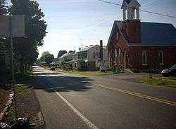 Pennsylvania Route 45 passes through Hartleton | |
 Location of Hartleton in Union County, Pennsylvania. | |
 Hartleton Location within the U.S. state of Pennsylvania  Hartleton Hartleton (the United States) | |
| Coordinates: 40°54′01″N 77°09′19″W | |
| Country | United States |
| State | Pennsylvania |
| County | Union |
| Settled | 1773 |
| Incorporated (borough) | 1858 |
| Area | |
| • Total | 0.91 sq mi (2.35 km2) |
| • Land | 0.91 sq mi (2.35 km2) |
| • Water | 0.00 sq mi (0.00 km2) |
| Elevation [2] (center of borough) | 650 ft (200 m) |
| Highest elevation [2] (western borough boundary by Harleton Cemetery) | 760 ft (230 m) |
| Lowest elevation [2] (Cold Run at southeast borough boundary) | 610 ft (190 m) |
| Population (2010) | |
| • Total | 283 |
| • Estimate (2017)[3] | 281 |
| • Density | 309.47/sq mi (119.44/km2) |
| Time zone | Eastern (EST) |
| • Summer (DST) | EDT |
| Zip code | 17829 |
| Area code(s) | 570 |
| FIPS code | 42-32936 |
Geography
Hartleton is located at 40°54′1″N 77°9′19″W (40.900148, -77.155229).[4]
According to the United States Census Bureau, the borough has a total area of 0.9 square miles (2.3 km2), all of it land.
Demographics
| Historical population | |||
|---|---|---|---|
| Census | Pop. | %± | |
| 1870 | 292 | — | |
| 1880 | 300 | 2.7% | |
| 1890 | 261 | −13.0% | |
| 1900 | 237 | −9.2% | |
| 1910 | 160 | −32.5% | |
| 1920 | 161 | 0.6% | |
| 1930 | 169 | 5.0% | |
| 1940 | 208 | 23.1% | |
| 1950 | 240 | 15.4% | |
| 1960 | 234 | −2.5% | |
| 1970 | 223 | −4.7% | |
| 1980 | 220 | −1.3% | |
| 1990 | 246 | 11.8% | |
| 2000 | 260 | 5.7% | |
| 2010 | 283 | 8.8% | |
| Est. 2017 | 281 | [3] | −0.7% |
| Sources:[5][6][7] | |||
As of the census[6] of 2000, there were 260 people, 89 households, and 71 families residing in the borough. The population density was 286.4 people per square mile (110.3/km²). There were 91 housing units at an average density of 100.2 per square mile (38.6/km²). The racial makeup of the borough was 97.31% White, and 2.69% from two or more races. Hispanic or Latino of any race were 0.38% of the population.
There were 89 households out of which 33.7% had children under the age of 18 living with them, 65.2% were married couples living together, 10.1% had a female householder with no husband present, and 20.2% were non-families. 19.1% of all households were made up of individuals and 14.6% had someone living alone who was 65 years of age or older. The average household size was 2.72 and the average family size was 3.11.
In the borough the population was spread out with 27.7% under the age of 18, 6.2% from 18 to 24, 26.9% from 25 to 44, 26.2% from 45 to 64, and 13.1% who were 65 years of age or older. The median age was 37 years. For every 100 females there were 104.7 males. For every 100 females age 18 and over, there were 97.9 males.
The median income for a household in the borough was $40,938, and the median income for a family was $42,188. Males had a median income of $31,250 versus $19,375 for females. The per capita income for the borough was $14,714. None of the families and 1.1% of the population were living below the poverty line.
References
- "2017 U.S. Gazetteer Files". United States Census Bureau. Retrieved Mar 24, 2019.
- "Laurel Run Topo Map, Union County PA (Beavertown Area)". TopoZone. Locality, LLC. Retrieved 27 November 2019.
- "Population and Housing Unit Estimates". Retrieved March 24, 2018.
- "US Gazetteer files: 2010, 2000, and 1990". United States Census Bureau. 2011-02-12. Retrieved 2011-04-23.
- "Census of Population and Housing". U.S. Census Bureau. Retrieved 11 December 2013.
- "U.S. Census website". United States Census Bureau. Retrieved 2008-01-31.
- "Incorporated Places and Minor Civil Divisions Datasets: Subcounty Resident Population Estimates: April 1, 2010 to July 1, 2012". Population Estimates. U.S. Census Bureau. Archived from the original on 11 June 2013. Retrieved 11 December 2013.
Municipalities and communities of Union County, Pennsylvania, United States | ||
|---|---|---|
| Boroughs | 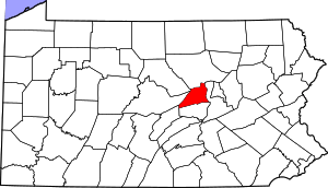 | |
| Townships | ||
| CDPs | ||
| Unincorporated communities | ||
| Authority control |
|
|---|