Harrison Township, Wells County, Indiana
Harrison Township is one of nine townships in Wells County, Indiana, United States. As of the 2010 census, its population was 8,531 and it contained 3,702 housing units.[2]
Harrison Township | |
|---|---|
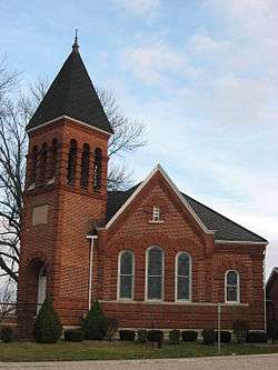 Bethel Methodist Church, a historic site in the township | |
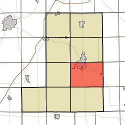 Location in Wells County | |
| Coordinates: 40°41′35″N 85°08′51″W | |
| Country | United States |
| State | Indiana |
| County | Wells |
| Government | |
| • Type | Indiana township |
| Area | |
| • Total | 48.26 sq mi (125.0 km2) |
| • Land | 47.83 sq mi (123.9 km2) |
| • Water | 0.43 sq mi (1.1 km2) 0.89% |
| Elevation | 837 ft (255 m) |
| Population (2010) | |
| • Total | 8,531 |
| • Density | 178.4/sq mi (68.9/km2) |
| Time zone | UTC-5 (Eastern (EST)) |
| • Summer (DST) | UTC-4 (EDT) |
| ZIP codes | 46714, 46781 |
| Area code(s) | 260 |
| GNIS feature ID | 453400 |
History
Six Mile Church, the first organized church in Wells County was formed in Harrison Township by Hallet Barber on September 2, 1838.
The Bethel Methodist Episcopal Church was listed on the National Register of Historic Places in 1984.[3]
Geography
According to the 2010 census, the township has a total area of 48.26 square miles (125.0 km2), of which 47.83 square miles (123.9 km2) (or 99.11%) is land and 0.43 square miles (1.1 km2) (or 0.89%) is water.[2]
Unincorporated towns
- Reiffsburg at 40.655879°N 85.151915°W
- Riverside at 40.696435°N 85.085247°W
- Travisville at 40.691991°N 85.208026°W
(This list is based on USGS data and may include former settlements.)
Adjacent townships
- Lancaster Township (north)
- Kirkland Township, Adams County (northeast)
- French Township, Adams County (east)
- Hartford Township, Adams County (southeast)
- Nottingham Township (south)
- Chester Township (southwest)
- Liberty Township (west)
- Rockcreek Township (northwest)
Cemeteries
The township contains these four cemeteries: Elm Grove, Grove, Linn and Saint Johns.
Rivers
Lakes
- Kunkel Lake
School districts
- Metropolitan School District of Bluffton-Harrison
Political districts
- Indiana's 6th congressional district
- State House District 82
- State Senate District 19
References
- United States Census Bureau 2007 TIGER/Line Shapefiles
- United States Board on Geographic Names (GNIS)
- IndianaMap
- "US Board on Geographic Names". United States Geological Survey. October 25, 2007. Retrieved 2017-05-09.
- "Population, Housing Units, Area, and Density: 2010 - County -- County Subdivision and Place -- 2010 Census Summary File 1". United States Census. Archived from the original on 2020-02-12. Retrieved 2013-05-10.
- "National Register Information System". National Register of Historic Places. National Park Service. July 9, 2010.
External links
Municipalities and communities of Wells County, Indiana, United States | ||
|---|---|---|
| City | Map of Indiana highlighting Wells County | |
| Towns | ||
| Townships | ||
| Unincorporated communities | ||
| Footnotes | ‡This populated place also has portions in an adjacent county or counties | |