Hareid (village)
Hareid is the administrative centre of Hareid Municipality in Møre og Romsdal county, Norway. The village is located on the eastern coast of the island of Hareidlandet, along the Sulafjorden. The village has a shopping center, some industry, a hotel, and Hareid Church.[3]
Hareid | |
|---|---|
Village | |
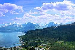 View of the village | |
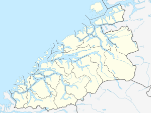 Hareid Location in Møre og Romsdal  Hareid Hareid (Norway) | |
| Coordinates: 62.3704°N 6.0290°E | |
| Country | Norway |
| Region | Western Norway |
| County | Møre og Romsdal |
| District | Sunnmøre |
| Municipality | Hareid Municipality |
| Area | |
| • Total | 2.57 km2 (0.99 sq mi) |
| Elevation | 3 m (10 ft) |
| Population (2018)[1] | |
| • Total | 3,428 |
| • Density | 1,334/km2 (3,460/sq mi) |
| Time zone | UTC+01:00 (CET) |
| • Summer (DST) | UTC+02:00 (CEST) |
| Post Code | 6060 Hareid |
The 2.57-square-kilometre (640-acre) village has a population (2018) of 3,428 and a population density of 1,334 inhabitants per square kilometre (3,460/sq mi).[1]
The Norwegian County Road 61 runs from Hareid to the town of Ulsteinvik on the other side of the island. There is also a ferry that runs between Hareid and Sulesund across the Sulafjorden on the island of Sula. There is another road heading north from Hareid to the village of Brandal, and it heads south to the village of Hjørungavåg.
References
- Statistisk sentralbyrå (1 January 2018). "Urban settlements. Population and area, by municipality".
- "Hareid (Møre og Romsdal)". yr.no. Retrieved 2019-09-07.
- Store norske leksikon. "Hareid – tettstedet" (in Norwegian). Retrieved 2013-08-02.
| Authority control |
|
|---|