Hammersbach
Hammersbach is a municipality in the district of Main-Kinzig-Kreis, in Hesse, Germany.
Hammersbach | |
|---|---|
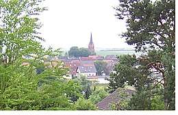 View of Hammersbach | |
.svg.png) Coat of arms | |
Location of Hammersbach within Main-Kinzig-Kreis district 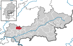  | |
 Hammersbach  Hammersbach | |
| Coordinates: 50°13′N 08°59′E | |
| Country | Germany |
| State | Hesse |
| Admin. region | Darmstadt |
| District | Main-Kinzig-Kreis |
| Subdivisions | 3 districts |
| Government | |
| • Mayor | Michael Göllner (SPD) |
| Area | |
| • Total | 20.15 km2 (7.78 sq mi) |
| Highest elevation | 160 m (520 ft) |
| Lowest elevation | 135 m (443 ft) |
| Population (2018-12-31)[1] | |
| • Total | 4,818 |
| • Density | 240/km2 (620/sq mi) |
| Time zone | CET/CEST (UTC+1/+2) |
| Postal codes | 63546 |
| Dialling codes | 06185 |
| Vehicle registration | MKK |
| Website | www.hammersbach.de |
Location
Hammersbach is located near Frankfurt am Main. Since 2007 Hammersbach has an official connection to the motorway A45 that has been planned for a long time. Prior to that, it was necessary to use the Raststätte Langen-Bergheim to get access the motorway.
Constituent communities
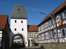
Untertor of Marköbel
It consists of two villages: Marköbel and Langen-Bergheim. Only Marköbel once belonged to the Roman Empire. Parts of the Limes were found there recently.
Culture and sightseeing
Hammersbach has many beautiful old houses in the town center. The elementary school (Astrid-Lindgren-Schule) of Hammersbach can be seen easily from the fields around the village, because of the cone-shaped roof.
References
- "Bevölkerungsstand am 31.12.2018". Hessisches Statistisches Landesamt (in German). July 2019.
External links
Towns and municipalities in Main-Kinzig-Kreis district | ||
|---|---|---|
| Wappen des Landkreises Main-Kinzig-Kreis | |
| Authority control |
|
|---|
This article is issued from Wikipedia. The text is licensed under Creative Commons - Attribution - Sharealike. Additional terms may apply for the media files.