Half Moon Bay, Auckland
Half Moon Bay, an affluent coastal suburb of Auckland, New Zealand, lies immediately south of Bucklands Beach. It formed part of Manukau City until the amalgamation of the entire Auckland Region in 2010 under one governing authority, Auckland Council.
Half Moon Bay | |
|---|---|
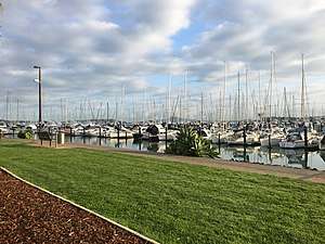 Marina at Half Moon Bay, September 2018 | |
 Half Moon Bay  Half Moon Bay | |
| Coordinates: 36°53′05″S 174°53′55″E | |
| Country | New Zealand |
| Local authority | Manukau |
| Established | 1969 |
| Postcode(s) | 2012 |
| Airport(s) | None |
| Wai o Taiki Bay | Bucklands Beach | |
|
|
Pakuranga | |
| Highland Park | Farm Cove | Botany Downs |
It is well known for the Half Moon Bay Marina, home to over 500 boats. It is located on the Tamaki Estuary in the Hauraki Gulf.
Half Moon Bay is the location of a long-established ferry terminal for vehicle and passenger traffic to Waiheke Island and for a regular passenger ferry service to downtown Auckland.
History
Prior to the construction of the marina complex in 1967 the muddy bay was known first as Hancock's Bay, after the Hancock family which farmed in the area, and then as Camp Bay due to the establishment of the King George V Health Camp.[1] Beneath the sandy top layer was a deep layer of fine quality pottery clay that was collected for the Pakuranga College art department and stored under the art department building in 1967.
The temporary edges of the land fill were created with the concrete debris from the old Panmure bridge which was demolished at the time the land fill was being created. Prior to the establishment of the marina the bay was very isolated with only eight houses and the Half Moon Bay Health Camp on the southwest headland.
References
- "History of Howick, Pakuranga and surrounding areas". Howick Welcome Guide. Howick and Pakuranga Times. 11 April 2005. Archived from the original on 20 February 2008.