Haldia Port
Haldia port [4][5] or Haldia Dock Complex has been built at the meeting place of the Haldi River and Hooghly river. Kolkata Port Trust has been created in this port as the port's partner. So it is not a port. It is an official dock complex.
| Haldia Port | |
|---|---|
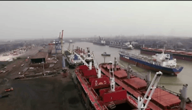 Aerial view of Haldia port | |
| Location | |
| Country | |
| Location | Haldia, West Bengal |
| Coordinates | 22.0447°N 88.0888°E |
| Details | |
| Opened | 1967 |
| Operated by | Kolkata Port Trust |
| Owned by | Ministry of Shipping (India) |
| Type of harbor | Larger river port/sea port |
| Available berths | 12 |
| Wharfs | 6 |
| General Manager | Amal Dutta |
| Draft | 8 metres (26 ft) |
| Statistics | |
| Annual cargo tonnage | 40.496 million tonnes (2017-2018) [1][2] |
| Annual container volume | 1,56,000 TEUs (2017-2018)[3] |
It has a vast hinterland comprising the entire north east of India including West Bengal, Bihar, Jharkhand, Uttar Pradesh, Madhya Pradesh, Assam, North East Hill States and two landlocked neighbouring countries namely, Nepal and Bhutan and also the Autonomous Region of Tibet (China).
With the turn of the century the volume of throughput has again started increasing steadily.
Geography
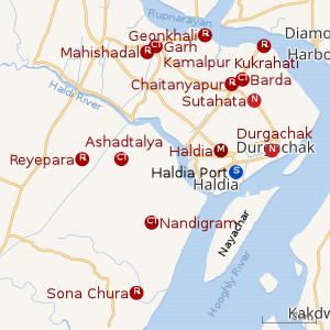 |
| Cities and towns in Haldia subdivision of Purba Medinipur district M: municipal city/ town, CT: census town, R: rural/ urban centre, S: port Owing to space constraints in the small map, the actual locations in a larger map may vary slightly |
Location
Haldia port is 8 meters above sea level and is located at 21.20 north and 88.00 east.[6]
Dock system
It is situated at 22°02′N 88°06′E around 60 kilometres (37 mi) away from the pilotage station. The port consists of:
- Impounded dock; system with 12 berths
- 3 oil jetties in the river
- 3 barge jetties in the river for handling oil carried by barges
- Haldia anchorage for lash vessels
The docks are impounded dock systems with locks from river.
Imports and exports
The port's main imports are petroleum, chemicals, and parts. Exports include coal, iron ore, and steel. 33 million tons of cargo were in the port 2014-2015.
References
- "Kolkata Port records highest traffic in 2017-18: Chairman Vinit Kumar". The Indian Express. 4 April 2018. Retrieved 23 April 2018.
- http://kolkataporttrusttyugfryuggyu.gov.in/index1.php?
- "Maersk extends 'one-stop shipper shop' solution to Haldia Port".
- "Port of HALDIA (IN HAL) details - Departures".
- "অচলাবস্থা কাটার মুখে হলদিয়া বন্দর, শুরু পণ্য খালাস". Archived from the original on 31 March 2017. Retrieved 31 March 2017.
- "Location Map of Haldia Sea Port".