Haigh Field Airport
Haigh Field Airport (FAA LID: O37) is a public airport located three miles (4.8 km) southeast of the central business district (CBD) of Orland, a city in Glenn County, California, USA. The airport covers 300 acres (121 ha) and has one runway. It is mostly used for general aviation and it was used to train pilots during war time.
Haigh Field Airport Orland Air Force Auxiliary Field | |||||||||||
|---|---|---|---|---|---|---|---|---|---|---|---|
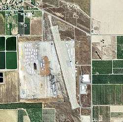 2006 USGS Photo | |||||||||||
| Summary | |||||||||||
| Airport type | Public | ||||||||||
| Operator | Glenn County | ||||||||||
| Location | Orland, California | ||||||||||
| Elevation AMSL | 215 ft / 65.5 m | ||||||||||
| Coordinates | 39°43′16″N 122°08′48″W | ||||||||||
| Map | |||||||||||
 O37 Location of Haigh Field Airport | |||||||||||
| Runways | |||||||||||
| |||||||||||
World War II
During World War II, the airport was designated as Orland Air Force Auxiliary Field, and was an auxiliary training airfield for Chico Army Airfield, California.
References
![]()
External links
- Resources for this airport:
- FAA airport information for O37
- AirNav airport information for O37
- FlightAware airport information and live flight tracker
- SkyVector aeronautical chart for O37
| Units |
| .svg.png) | ||||||||||||||
|---|---|---|---|---|---|---|---|---|---|---|---|---|---|---|---|---|
This article is issued from Wikipedia. The text is licensed under Creative Commons - Attribution - Sharealike. Additional terms may apply for the media files.