Hadejia
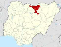
Hadejia (also Hadeja, previously Biram) is a Hausa town in eastern Jigawa State, northern Nigeria. The population was approximately 105,628 in 2006.[1] Hadejia lies between latitude 12.4506N and longitude 10.0404E.[2] It shared boundary with Kirikasamma Local Government from the East, Mallam Madori Local Government from the North, and Auyo Local Government from the West. The Hadejia Local Government consist of eleven (11) political wards namely: Atafi, Dubantu, Gagulmari, Kasuwar Kofa, Kasuwar Kuda, Matsaro, Majema, Rumfa, Sabon Garu, Yankoli and Yayari. Inhabitant are dominantly Hausa, Fulani and Kanuri with some other races such as Tiv, Yaroba, Igbo, Igala etc. The dominant occupation of the inhabitants is crop farming and animal rearing which a considerable percentage, engaged in trading, fishing and services including civil service.[3] The people of Hadejia are largely Muslim, although some follow indigenous belief systems. The town lies to the north of the Hadejia River, and is upstream from the Hadejia-Nguru wetlands. Hadejia is an internationally important ecological and sensitive zone.[4]
Hadejia Biram | |
|---|---|
LGA and town | |
| Nickname(s): Ginsau Birnin Doki | |
| Motto(s): Majestic City of Stallion | |
 Hadejia | |
| Coordinates: 12°27′N 10°2′E | |
| Country | |
| State | Jigawa State |
| Time zone | UTC+1 (WAT) |
Hadejia was once known as Biram, and is referred to as one of the "seven true Hausa states" (Hausa Bakwai),[5] because it was ruled by the descendants of the Hausa mythological figure Bayajidda and his second wife, Daurama.[6] By 1810, during the Fulani War, the Hausa rulers of the Hausa Bakwai had all been overcome by the Fulani.[7] Hadejia had been transformed into an Emirate two years earlier, in 1808. In 1906 Hadejia resisted British occupation, under the then Emir (Muhammadu Mai-Shahada). Hadejia was absorbed into Jigawa State in 1991 from Kano State.
The Hadejia consist of 4 tertiary institutions namely: Binyaminu Usman Polytechnic Hadejia,[8] School of Nursing Hadejia,[9] National Teachers Institutes Hadejia Study Centre[10]
References
- "Hadejia". Encyclopædia Britannica. Encyclopædia Britannica, Inc. Retrieved 2006-12-22.
- GPS Coordinates: "https://latitude.to/map/ng/nigeria/cities/hadejia"
- Isah Abubakar (2018) "Use of ICT among Extension Agents in Hadejia Local Government" Unpublished work
- Muhammad J. Chiroma; Yahaya D. Kazaure; Yahya B. Karaye; Abba J. Gashua. "Water Management Issues in the Hadejia-Jama'are-Komadugu-Yobe Basin: DFID-JWL and Stakeholders Experience in Information Sharing, Reaching Consensus and Physical Interventions" (PDF). International Water Management Institute. Retrieved 2009-10-03.
- "Daura". Encyclopædia Britannica. Encyclopædia Britannica, Inc. Retrieved 2006-12-21.
- Dierk Lange. "Oral version of the Bayajidda legend" (PDF). Ancient Kingdoms of West Africa. Retrieved 2006-12-21.
- Johnston, H. A. S (1967). "The Consolidation of the Empire". The Fulani Empire of Sokoto. Amana Online. Retrieved 2007-01-21.
- http://www.bupoly.edu.ng
- http://jisconmhadejia.admissions.cloud/
- http://www.nti.edu.ng
External links
State capital: Dutse | ||
| Local Government Areas |
|  |