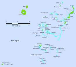
Haʻapai
Haʻapai is a group of islands, islets, reefs and shoals with an area of 109.30 square kilometres (42.20 sq mi) in the central part of the Kingdom of Tonga, with the Tongatapu group to the south and the Vavaʻu group to the north. Seventeen of the Haʻapai islands are populated with altogether 6,125 people. Its highest point is Kao at almost 1,050 metres (3,440 ft).
 Map of Haʻapai | |
| Geography | |
|---|---|
| Location | Pacific Ocean |
| Coordinates | 20°0′S 174°40′W |
| Archipelago | Tonga Islands |
| Total islands | 51 |
| Major islands | 17 |
| Area | 109.30 km2 (42.20 sq mi) |
| Highest elevation | 1,046 m (3,432 ft) |
| Highest point | Kao |
| Administration | |
Tonga | |
| Largest settlement | Pangai, Lifuka Island |
| Demographics | |
| Population | 6125 (2016) |
| Pop. density | 60.53/km2 (156.77/sq mi) |
| Ethnic groups | Tongan (majority), European, Chinese, Pacific Islanders |
Pangai is the administrative capital village of Haʻapai District and is located on Lifuka.
Geography

Haʻapai consists of 51 islands directly west of the Tonga Trench, constituting a chain of both volcanic and coral islands including Kao, the highest point in the kingdom standing at 1,046 metres (3,432 ft);further to the east are the coral islands which are inhabited. The archipelago lies 204 kilometres (127 mi) north of Tongatapu and 130 kilometres (81 mi) south of Vavaʻu. Seventeen of the islands are inhabited, including the main islands of Lifuka and Foa. The two main villages in the archipelago are Pangai on Lifuka (where Salote Pilolevu Airport is located) and Ha'ano. A total of 7212 people live on the Ha'apai islands (Census 2011[1]).
All the larger islands are in the eastern Lifuka group. The two larger islands are Lifuka and Foa which have 2,968 and 1,485 people respectively as of 2006. After the two larger islands are Nomuka and Haʻano which have four villages with a population of 951. To the south of these islands is ʻUiha, which has two villages with a population of 638, ancient burial grounds and an ancient monument.
The large islands of Tofua (active volcano) and Kao (dormant volcano) are in the far west. The islands of the Kotu group, locally known as Lulunga, are in the southwest of the archipelago. The islands of the Nomuka group, locally known as ʻOtu Muʻomuʻa, are further south.
Humpback whales migrate here in wintering seasons.[2]
History

At the Haʻapai island group, traces of settlements of Lapita culture from around 1500 BC have been found.
The first European to visit Haʻapai, was Abel Tasman in 1643. Captain James Cook in 1774 and 1777, made several stops on the islands. He gave them the name of Friendly Islands in 1777.
On 18 May 1777, Cook arrived with Omai. They were greeted by Fatafehi Paulaho, 'King of the Isles' or Tu'i Tonga, the most sacred chief in these islands.[3]
On 28 April 1789, the Haʻapai island group was the site of the Mutiny on the Bounty; Captain William Bligh visited the volcanic island Tofua shortly after being set adrift following the mutiny.
In 1806, William Mariner arrived aboard the Port-au-Prince, whose crew was killed at this occasion by Tongan warriors. Mariner lived four years in Tonga, before he was found by a passing English ship returning to England.
The US Exploring Expedition met with George (Taufa'ahau), chief of Ha'apai, in 1840.[4]
References
- http://www.mic.gov.to/news-today/press-releases/3220-tonga-national-population-census-2011-preliminary-count
- Amarula Sail. 2016. The last place on earth you would expect to find a vet!. Retrieved on April 05, 2017
- Salmond, Anne (2010). Aphrodite's Island. Berkeley: University of California Press. pp. 408-412. ISBN 9780520261143.
- Stanton, William (1975). The Great United States Exploring Expedition. Berkeley: University of California Press. pp. 187. ISBN 0520025571.