Haʻena State Park
Hāʻena State Park is a state park located on the north shore of the Hawaiian island of Kauaʻi. It is often referred to as the "end of the road" and marks the end point of the Kuhio Highway.[2] The park provides access to beaches, trails, and several ancient Hawaiian sites, including sea caves estimated to be more than 4,000 years old. Archaeological sites associated with the hula, including a heiau (shrine) dedicated to Laka, are located above the park's beaches.[3]
| Hāʻena State Park | |
|---|---|
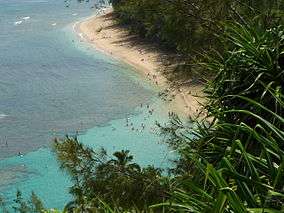 Keʻe Beach from the Kalalau Trail | |
  | |
| Location | Hawaii, U.S. |
| Nearest city | Hanalei, Hawaii |
| Coordinates | 22°13′15″N 159°34′42″W[1] |
| Area | 230 acres (93 ha) |
| Governing body | Hawai'i Department of Land and Natural Resources |
| www | |
Description
A little over an hour's drive from Lihue and 5 miles (8.0 km) west of Hanalei, Hawaii, the 230-acre park is at the terminus of the Kuhio Highway (Hawaii Route 560) at 22°13′15″N 159°34′42″W.[4]
The small parking lot was not large enough to accommodate all the visitors, so an overflow parking lot was built. Though the beach has a relatively safe lagoon, very strong currents have been reported at the bay, especially in the winter. Amenities at the park include pay phones, picnic tables, restrooms and outdoor showers.[1]
Limahuli Stream enters the ocean at the eastern edge of the state park. To the south of the park, Makana mountain soars above Limahuli Garden and Preserve in the valley.[5] Just before the Kēʻē beach is the Kalalau Trail trailhead, an 11-mile (18 km) footpath that is the only land access into the Nā Pali Coast State Park. The area surrounding the beaches is vegetated by ironwood trees, coconut palms, ti, and guava.
Beaches

- Kēʻē Beach is located at the western edge of the park.[6] This beach is located west from "Tunnels Beach" (aka "Makua Beach" at Haena Point),[7] which refers to the large waves that are thought to be ideal for surfing.[8] Kēʻē Beach has a unique reef lagoon, which allows the water to be calm and attractive for snorkeling and swimming.[9] Beyond the reef, however, very strong currents, especially in the winter, have been reported. In Hawaiian, Kēʻē literally translates to "avoidance", referring to stories in Hawaiian mythology about the goddess Pele and Lohiʻau.[10]
- Hāʻena Beach is located just to the east of Haʻena State Park. Haena is Hawaiian and literally translates to "red hot".[11] The beach is located at: 22°13′17″N 159°33′41″W.[12]
References
- "Hā'ena State Park". Hawaii State Parks web site. Retrieved October 13, 2010.
- Luci Yamamoto (2006). Kaua'i. Lonely Planet. p. 154. ISBN 978-1-74059-096-9.
- John R. K. Clark (2004). "lookup of Kēʻē ". in Hawai'i Place Names: Shores, Beaches, and Surf Sites. Ulukau, the Hawaiian Electronic Library, University of Hawaii Press. Retrieved October 13, 2010.
- U.S. Geological Survey Geographic Names Information System: Hāʻena State Park Retrieved October 13, 2010.
- U.S. Geological Survey Geographic Names Information System: Limahuli Stream
- U.S. Geological Survey Geographic Names Information System: Kē‘ē Beach Retrieved October 13, 2010.
- U.S. Geological Survey Geographic Names Information System: Tunnels Beach
- John R. K. Clark (2004). "lookup of Tunnels ". in Hawai'i Place Names: Shores, Beaches, and Surf Sites. Ulukau, the Hawaiian Electronic Library, University of Hawaii Press. Retrieved October 13, 2010.
- Kauai County Visitors Bureau
- Mary Kawena Pukui, Samuel Hoyt Elbert and Esther T. Mookini (2004). "lookup of Kēʻē ". in Place Names of Hawai'i. Ulukau, the Hawaiian Electronic Library, University of Hawaii Press. Retrieved October 13, 2010.
- Pukui, Mary Kawena. Place Names of Hawaii. University of Hawaii Press. ISBN 0-8248-0524-0.
- U.S. Geological Survey Geographic Names Information System: Hā‘ena Retrieved October 13, 2010.
External links
- Save Our Seas -Haena.org
- "Keʻe Beach A.K.A. Ha'ena State Park, End-of-the-Road". Kauaʻi explorer web site. Kauaʻi Visitors Bureau. Retrieved October 13, 2010.
| Authority control |
|---|