Hōei eruption
The Hōei eruption of Mount Fuji started on 16 December 1707 (23rd day of the 11th month of the year Hōei 4) and ended about 1 January 1708 (9th day of the 12th month of the year Hōei 4) during the Edo period.[2] Today the crater of the main eruption can be visited from the Fujinomiya or Gotemba Trails on Mount Fuji. Hokusai's One Hundred Views of Mount Fuji includes an image of the small crater at a secondary eruption site on the southwestern slope. This was called Mount Hōei, because the eruption occurred in the fourth year of Hōei.[3]
| Hōei eruption | |
|---|---|
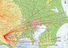 Map of volcanic ash fall during the Hoei eruption | |
| Volcano | Mount Fuji |
| Start date | December 16, 1707[1] |
| End date | February 24, 1708[1] |
| Type | Plinian eruption |
| Location | Chūbu region, Honshu, Japan 35.3580°N 138.7310°E |
| VEI | 5[1] |
Extent of eruption
Although it brought no lava flow, the Hōei eruption released some 800 million cubic metres (28×109 cu ft) of volcanic ash, which spread over vast areas around the volcano, even reaching Edo almost 100 kilometres (60 mi) away. Cinders and ash fell like rain in Izu, Kai, Sagami, and Musashi provinces.[4] In Edo, the volcanic ash was several centimetres thick.[5] The eruption is rated a 5 on the Volcanic Explosivity Index.[6]
The eruption happened on Mount Fuji's east–north-east flank and formed three new volcanic vents, named No. 1, No. 2, and No. 3 Hōei vents. The catastrophe developed over the course of several days; an initial earthquake and explosion of cinders and ash was followed some days later with the more forceful ejections of rocks and stones.[3] Mount Fuji has not erupted since.
Secondary disasters
In the year following the Hōei eruption, a secondary disaster occurred when the Sakawa river flooded due to sediment build-up resulting from the ash fall.
Volcanic ash fell and widely covered the cultivated fields east of Mount Fuji. To recover the fields farmers cast volcanic products out to dumping-grounds making piles. The rain washed material from the dumping grounds away to the rivers again and again and made some of the rivers shallower, especially into the Sakawa river, into which huge volumes of ash fell, resulting in temporary dams. Heavy rainfall on 7–8 August 1708, the year following the Hōei eruption, caused an avalanche of volcanic ash and mud, breaking the dams and flooding the Ashigara plain.[7]
Notes
- "Fujisan". Global Volcanism Program. Smithsonian Institution. Retrieved 2019-01-12.
- Shizuoka University page
- Smith, Henry. (1988). Hokusai: One Hundred Views of Mt. Fuji. p. 197.
- Titsingh, Isaac. (1834). Annales des empereurs du japon, p. 416.
- Archived March 25, 2011, at the Wayback Machine
- "Fuji — Eruption History". Global Volcanism Program. Smithsonian Institution. Retrieved 10 August 2013.
- "A Premodern History of the Odowara". Zombie Zodiac. November 17, 2014. Retrieved November 15, 2016.
References
- Titsingh, Isaac. (1834). [Siyun-sai Rin-siyo/Hayashi Gahō, 1652]. Nipon o daï itsi ran; ou, Annales des empereurs du Japon. Paris: Oriental Translation Society of Great Britain and Ireland.
- Smith, Henry D. (1988). Hokusai: One Hundred Views of Mt. Fuji. New York: George Braziller. ISBN 978-0-8076-1453-2 (paper)
External links
- 富士山火山防災協議会 (Council for Fuji volcano disaster reduction)
- 富士山宝永噴火(1707)後の土砂災害(PDF)(Distribution of sediment disasters after the 1707 Hoei eruption of Fuji Volcano in central Japan, based on historical documents)