Guigneville
Guigneville is a commune in the Loiret department in north-central France.
Guigneville | |
|---|---|
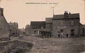 An old postcard view of Guigneville | |
Location of Guigneville 
| |
 Guigneville  Guigneville | |
| Coordinates: 48°12′25″N 2°10′41″E | |
| Country | France |
| Region | Centre-Val de Loire |
| Department | Loiret |
| Arrondissement | Pithiviers |
| Canton | Pithiviers |
| Intercommunality | Communauté de communes de Beauce et du Gâtinais |
| Government | |
| • Mayor (2001–2008) | Jean-Claude Bouvard |
| Area 1 | 32.01 km2 (12.36 sq mi) |
| Population (2017-01-01)[1] | 529 |
| • Density | 17/km2 (43/sq mi) |
| Demonym(s) | Guignevillois |
| Time zone | UTC+01:00 (CET) |
| • Summer (DST) | UTC+02:00 (CEST) |
| INSEE/Postal code | 45162 /45300 |
| Elevation | 117–141 m (384–463 ft) |
| 1 French Land Register data, which excludes lakes, ponds, glaciers > 1 km2 (0.386 sq mi or 247 acres) and river estuaries. | |
Origin of the name town
In 1793, the commune was already under the name of Guigneville.
Geography
The commune is in the north of the department, in the Grande Beauce, large cereal area with a gentle slope, which is part of the nine natural region of the Loiret. It is located at 7.9 km from the road of its canton, Pithiviers, (13 min from the road in normal traffic conditions), and at 64 km (53 min) from its departmental préfecture, in Orléans. The departmental roads 22, 23 et 134 cross the territory of the commune.
Heritage
Saint-Hilaire church was built in the 12th century and listed into the historical monuments since 6 March 1928. It is holding a copy of a painting from Jean Jouvenet representing the Visitation of the Virgin created by the choral of the cathedral Notre-Dame de Paris, dated from the 17th century and classified as an object 5 December 1908. This copy was originally created in Saint-Benoît-sur-Loire Abbaye.
See also
| Wikimedia Commons has media related to Guigneville. |
| Authority control |
|
|---|
- "Populations légales 2017". INSEE. Retrieved 6 January 2020.