Guachama Rancheria
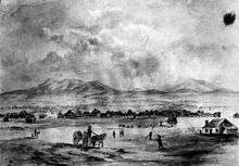
Guachama Rancheria was the place the Guachama Native Californians lived. The villages, or as the Spanish called them, Rancheria, were located what is now Loma Linda, California. Guachama Rancheria was designated a California Historic Landmark (No.95) on March 29, 1933. A marker was placed at 25894 Mission Road, Loma Linda, California to designate were the villages were. Translated, "Guachama" means a "place where there is plenty to eat". There were fresh springs and creeks in the area, thus providing ample food. Nearby was the Jumuba rancheria, another group of villages, that also start mission farming and cattle ranching. In 1772 Spanish exploration of the area started. Mission San Gabriel started to look at what is now the Loma Linda (beautiful hill) and Redlands lands in 1810, as a place to start a mission outpost. Father Francisco Dumetz (?-1811) came to the area and started Rancho San Bernardino on May 20, 1810 as an outpost of the Mission San Gabriel. Rancho San Bernardino became the headquarters of farming and cattle ranching in the area. The Guachama were taught to farm and care for cattle. Zanja trenches were made to bring water to more farm land. Guachama Rancheria from this time was called San Bernardino. In 1819 it was officially renamed San Bernardino Rancho of the Mission San Gabriel. Due to flooding from San Timoteo Creek, the mission was moved to higher ground in 1830. The Guachama were probably a branch of the Tongva/Gabrieleno tribes. Some ruins remain at the site.[1][2][3][4] [5]
| Guachama Rancheria | |
|---|---|
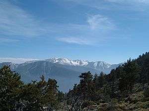 San Bernardino mountains above Redlands | |
| Location | Loma Linda, California |
| Coordinates | 34°03′23″N 117°14′17″W |
| Designated | March 29, 1933 |
| Reference no. | 95 |
 Location of Guachama Rancheria in California | |
In 1842, Mexico Governor Juan B. Alvarado gave a Mexican land grant to José del Carmen Lugo, José María Lugo, Vicente Lugo, and Diego Sepulveda. The grant covered 35,509-acre (143.70 km2) of what today is part of the San Bernardino valley, San Bernardino, Fontana, Rialto, Redlands and Colton.[6][7] [8] [9]
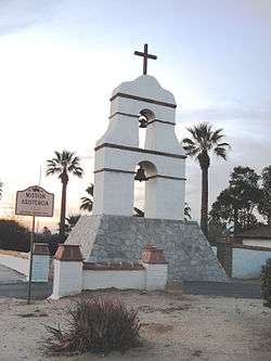
Markers
Marker at the site reads:
- NO. 95 GUACHAMA RANCHERIA - Guachama Rancheria, renamed San Bernardino on May 20, 1810 by Francisco Dumetz, became the San Bernardino Rancho of the Mission San Gabriel in 1819. The adobe administration building stood 70 yards north of this spot, an enramada served as the chapel, and a zanja was constructed to bring water from the mountains for irrigation. Control by mission fathers ended in 1834." Erected 1932 by Arrowhead Chapter Daughters of the American Revolution.
See also
References
- Marker Database, 'Guachama Rancheria
- San Bernardino, Jumuba
- San Bernardino, Pageant of History Begins to Unfold, By L. BURR BELDEN, Sun-Telegram Historical Writer, 1960
- Schuiling, Walter C. San Bernardino County: Land of Contrasts, Windsor Publications, 1984, p. 26
- "City of San Bernardino – Mission Road". Sbcity.org. 1937-10-10. Retrieved 2016-03-08.
- Diseño del Rancho San Bernardino
- Ogden Hoffman, 1862, Reports of Land Cases Determined in the United States District Court for the Northern District of California, Numa Hubert, San Francisco
- Caballeria y Collell, Juan, HISTORY OF SAN BERNARDINO VALLEY, from the padres to the pioneers, 1810-1851, Times-Index Press, San Bernardino, Cal., 1902.
- Historic Spots in California: Fifth Edition, By Douglas E. Kyle, Hero Eugene Rensch, Ethel Grace Rensch, Mildred Brooke Hoover, William
| Topics |  | |
|---|---|---|
| History | ||
| Areas | ||
| Transportation | ||
| Points of interest | ||
| Higher education | ||
| Sports | ||