Gschwandt
Gschwandt is a municipality in the district of Gmunden in the Austrian state of Upper Austria.
Gschwandt | |
|---|---|
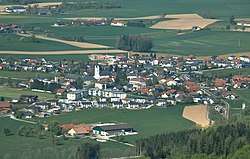 Gschwandt seen from the southwest | |
 Coat of arms | |
 Gschwandt Location within Austria | |
| Coordinates: 47°56′6″N 13°50′44″E | |
| Country | Austria |
| State | Upper Austria |
| District | Gmunden |
| Government | |
| • Mayor | Friedrich Steindl (ÖVP) |
| Area | |
| • Total | 16.76 km2 (6.47 sq mi) |
| Elevation | 523 m (1,716 ft) |
| Population (2018-01-01)[2] | |
| • Total | 2,750 |
| • Density | 160/km2 (420/sq mi) |
| Time zone | UTC+1 (CET) |
| • Summer (DST) | UTC+2 (CEST) |
| Postal code | 4816 |
| Area code | 07612 |
| Vehicle registration | GM |
| Website | www.oberoesterreich. at/gschwandt |
Geography
Gschwandt lies in a hilly area with a view on the Traunstein. About 18 percent of the municipality is forest, and 71 percent is farmland.
References
- "Dauersiedlungsraum der Gemeinden Politischen Bezirke und Bundesländer - Gebietsstand 1.1.2018". Statistics Austria. Retrieved 10 March 2019.
- "Einwohnerzahl 1.1.2018 nach Gemeinden mit Status, Gebietsstand 1.1.2018". Statistics Austria. Retrieved 9 March 2019.
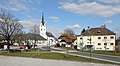 Center of Gschwandt
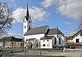 Parish church
This article is issued from Wikipedia. The text is licensed under Creative Commons - Attribution - Sharealike. Additional terms may apply for the media files.