Grytten Church
Grytten Church (Norwegian: Grytten kyrkje) is a parish church of the Church of Norway in Rauma Municipality in Møre og Romsdal county, Norway. It is located near the mouth of the Rauma River in the village of Veblungsnes. It is the church for the Grytten parish which is part of the Indre Romsdal prosti (deanery) in the Diocese of Møre. The red, wooden church was built in a octagonal style in 1829 by the architect S.H. Aspaas, possibly using the Sør-Fron Church as a model. The church seats about 250 people.[1][2]

| Grytten Church | |
|---|---|
| Grytten kyrkje | |
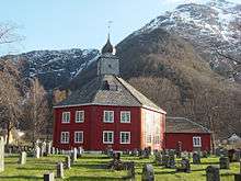 View of the church | |
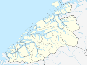 Grytten Church Location of the church  Grytten Church Grytten Church (Norway) | |
| 62.5528°N 7.6732°E | |
| Location | Rauma Municipality, Møre og Romsdal |
| Country | Norway |
| Denomination | Church of Norway |
| Churchmanship | Evangelical Lutheran |
| History | |
| Status | Parish church |
| Architecture | |
| Functional status | Active |
| Architect(s) | S.H. Aspaas |
| Architectural type | Octagonal |
| Completed | 1829 |
| Specifications | |
| Capacity | 250 |
| Materials | Wood |
| Administration | |
| Parish | Grytten |
| Deanery | Indre Romsdal prosti |
| Diocese | Møre |
There are four large columns which support the tower. Inside the church, there is a tall, 2-metre (6 ft 7 in) wide wooden crucifix, possibly from the 13th century. The church has a so-called pulpit altar (German: Kanzelaltar), which is a pulpit centrally located directly above the altar (according to the style of Sør-Fron Church). The two church bells are from the previous churches.[3][4]
History
The earliest existing historical records of Grytten Church date back to 1364. Originally, the church stood at the Grytten (or "Grytina") farm (that gave name to the church, parish, and municipality) which is located between the rivers Istra and Rauma, about 4 kilometres (2.5 mi) southeast of the present location. The historic name was «Gryttinar kirkja» which is mentioned in Aslak Bolt's cadastre. That building was a stave church and by 1642, it was in great need of repair. The medieval stave church was replaced in 1651, but the new building fell apart after less than 80 years. The building was already in need of some renovation in 1663 and in 1670 it received a new altarpiece. In 1690, the tower was taken down. In 1728, some of the beams in the church were began to fail and on 29 November 1728, the church roof and walls failed and the church crumbled.[5]
A new timber-framed cruciform church was built on the same site in 1732 and it stood on the site for about 100 years. During this time the church began to be threatened by shifting sands along the river banks. Shifting sand was a major problem in the area and large parts of the vicarage (which according to tradition included substantial farmland) was turned into a sand desert. In 1824, a sand dune "9 cubits tall" (about 3 metres or 9.8 feet) was located just east of the church and the church yard was largely covered in sand. The building itself suffered damages from sand penetrating cracks in the walls. So, the church building was dismantled, moved to Veblungsnes, about 4 kilometres (2.5 mi) to the northwest, along the fjord, and the church was rebuilt there. Some building materials were reused at the new site, but the church got a totally new shape. The rebuilt church was an octagonal design with an onion dome. The building has an altarpiece from the previous church building that dates back to the 13th century.[6] J.F.L. Dreier's 1826 lithography «Udsigten ved Grytten i Romsdalen» (View of Grytten in Romsdal) shows the old cruciform church with «de merkværdige Fielde» (the peculiar summits) of the mountains Bispen, Kongen, and Dronninga behind.[7][3][4][8]
Media gallery
 Exterior front
 Exterior back
 Photo from 1869
.jpg)


See also
- List of churches in Møre og Romsdal
References
- "Grytten kirke". Kirkesøk: Kirkebyggdatabasen. Retrieved 2019-07-05.
- "Oversikt over Nåværende Kirker" (in Norwegian). KirkeKonsulenten.no. Retrieved 2019-07-05.
- Thaule, John Ove; Ubostad, Ingar; Pedersen, Bjørn (1990). "Kyrkjene våre". Ei bok om Rauma (in Norwegian). Rauma Kommune. pp. 207–210.
- Grytten Kirke 175 år (in Norwegian). Grytten menighetsråd. 2004.
- "Grytten gamle kirkested" (in Norwegian). Norwegian Directorate for Cultural Heritage. Retrieved 2019-07-05.
- Helland, Amund (1911). Norges land og folk. Topografisk-statistisk beskrevet. Romsdals amt. Kristiania: Aschehoug.
- "JFL Dreier's picture". DigitaltMuseum.
- "Grytten kirkested / Grytten kirke 3" (in Norwegian). Norwegian Directorate for Cultural Heritage. Retrieved 2019-07-05.
Church of Norway churches in the Indre Romsdal prosti in Møre og Romsdal county, Norway | |||
|---|---|---|---|