Griffenfeld Island
Griffenfeld Island, Griffenfeldt Island,[1] (Danish: Griffenfeld Ø) or Umanaq ("the mountain in the shape of a heart"), after the name of the highest peak.[2] is an uninhabited island in the Sermersooq municipality in southern Greenland.
| Native name: Umanaq | |
|---|---|
 Griffenfeld Island | |
| Geography | |
| Location | North Atlantic Ocean Southern Greenland |
| Coordinates | 62°56′N 41°33′W |
| Highest elevation | 701 m (2,300 ft) |
| Highest point | Umanaq |
| Administration | |
Greenland | |
| Municipality | Sermersooq |
| Demographics | |
| Population | 0 |
History
The island was named after Danish Statesman Count Peder Griffenfeld (1635–1699) by Wilhelm August Graah during his 1829 expedition to the east coast of Greenland. Graah thought that he could see the distant Niviarsiat peaks, on the western side of the Greenland ice sheet, from the highest point of Griffenfeldt Island
They were probably, the tops of Niviarsiet, or The Maidens, in the district of Juliana's Hope.[3]
Fridtjof Nansen discovered old Eskimo ruins at the foot of Umanaq mountain in 1882.[4]
Knud Rasmussen visited the island in 1932, in the course of his Sixth Thule Expedition and described Griffenfeld Island as "barren and exposed to the fogs and winter ice of the sea".[5]
Geography
Griffenfeld Island is a coastal island located off King Frederick VI Coast in southeastern Greenland, separated from the mainland by a narrow sound. It lies south of the mouth of Sehested Fjord and Kattertooq, and north of the mouth of Timmiarmiut Fjord.[6] Its length is 14 kilometres (9 miles) and its maximum width 5.5 kilometres (3 miles).[7]
The island's coast is deeply indented and off its shore lie several small islets.[8]
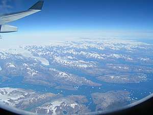 Picture of the Sehested Fjord mouth area with Griffenfeld Island in the lower right corner. |
 1944 map of the area around Skjoldungen with Griffenfeld Island as "Umang". |
See also
References
- James Nicol, An Historical and Descriptive Account of Iceland, Greenland, and the Faroe Islands, p. 228
- Den grønlandske Lods - Geodatastyrelsen
- W.A. Graah, Narrative of an Expedition to the East Coast of Greenland, London, 1837 p. 85
- Geographical Items on East Greenland : Encyclopedia Arctica 14
- Spencer Apollonio, Lands That Hold One Spellbound: A Story of East Greenland, 2008 p. 204
- GoogleEarth
- Prostar Sailing Directions 2005 Greenland and Iceland Enroute, p. 101
- "Griffenfeld Ø". Mapcarta. Retrieved 27 May 2019.