Greysteel
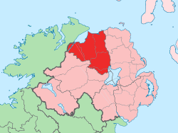
Greysteel or Gresteel[1] is a village in County Londonderry, Northern Ireland. It lies 9 miles (14 km) to the east of Derry and 7 miles (11 km) to the west of Limavady on the main A2 coast road between Limavady and Derry, overlooking Lough Foyle. It is designated as a Large Village and in the 2001 Census it had a population of 1,229 people,[2] an increase of almost 20% compared to 1991.[3] It is situated within Causeway Coast and Glens district.
Greysteel
| |
|---|---|
 Location within Northern Ireland | |
| Population | 1,229 (2001 Census) |
| District | |
| County | |
| Country | Northern Ireland |
| Sovereign state | United Kingdom |
| Postcode district | BT |
| Dialling code | 028 |
| Police | Northern Ireland |
| Fire | Northern Ireland |
| Ambulance | Northern Ireland |
| UK Parliament | |
| NI Assembly | |
History
The village lies mostly within the townlands of Gresteel More and Gresteel Beg. The name "Greysteel" may be a part-translation of the Irish Glas-stiall, meaning "grey strip (of land)",[4] and the Placenames Database of Ireland gives this as the Irish name of the village.[1] An older English name for the area was "Glasteele".[4]
The Troubles
During the Troubles, nine people were killed in the Greysteel area:
- On 14 November 1976, Jim Loughrey was shot dead by loyalists at his home.
- On 30 October 1993, members of the Ulster Defence Association carried out a mass shooting at the Rising Sun public house, killing eight civilians. This became known as the Greysteel massacre.
Features
Until relatively recently, the village had limited local facilities, with a modest sized general shop, a few other retail units, a primary school, a Gaelic club with playing fields and several public houses. However, the recent construction of the Vale Centre, developed by Greysteel Community Enterprise, a local development group, includes a range of commercial/industrial units and playing fields and has improved the situation.
A range of activities is available in the Centre, including an after school club, adult learning centre and sports facilities. Commercial facilities in the Centre, provide an opportunity for small business start-ups and a further 10 units are currently under construction. The village has grown considerably during the Post War period, mostly through new public sector housing up to the 1970s, and subsequently through considerable private housing development.
Places of interest
- Nearby Faughanvale Old church dates back to the medieval period and is dedicated to Saint Canice.[5]
Transport
The village is adequately served in terms of public transport and City of Derry Airport is located 4 km to the west.[3]
Sport
- Faughanvale GAC is the local Gaelic Athletic Association club.
2001 Census
Greysteel is classified as a village by the NI Statistics and Research Agency (NISRA) (i.e. with a population between 1,000 and 2,250 people). On Census day (29 April 2001) there were 1,229 people living in Greysteel. Of these:
- 25.4% were aged under 16 years and 11.7% were aged 60 and over
- 50.2% of the population were male and 49.8% were female
- 96.6% were from a Catholic background and 2.9% were from a Protestant background
- 0.8% of people aged 16–74 were unemployed.
For more details see: NI Neighbourhood Information Service
References
- Placenames Database of Ireland
- "Area Profile of Greysteel - Based on 2001 Census". NI Neighbourhood Information Service. Retrieved 23 June 2008.
- "Greysteel Settlement Designation". Planning Service - Draft Northern Area Plan 2016. Retrieved 23 June 2008.
- Placenames NI: Gresteel Beg
- "Greysteel". Culture Northern Ireland. Archived from the original on 9 June 2008. Retrieved 23 June 2008.