Greystanes, New South Wales
Greystanes is a suburb in Greater Western Sydney, New South Wales, Australia. Greystanes is located 29 kilometres west of the Sydney central business district in the local government area of Cumberland Council. Founded in the 1790s, Greystanes is one of the oldest suburbs in Sydney.
| Greystanes Greater Western Sydney, New South Wales | |||||||||||||||
|---|---|---|---|---|---|---|---|---|---|---|---|---|---|---|---|
 Greystanes library | |||||||||||||||
| Population | 22,802 (2016 census)[1] | ||||||||||||||
| • Density | 2,530/km2 (6,600/sq mi) | ||||||||||||||
| Established | 1799 | ||||||||||||||
| Postcode(s) | 2145 | ||||||||||||||
| Area | 9 km2 (3.5 sq mi) | ||||||||||||||
| Location | 29 km (18 mi) west of Sydney CBD | ||||||||||||||
| LGA(s) | Cumberland Council | ||||||||||||||
| Region | Western Sydney | ||||||||||||||
| County | Cumberland[2] | ||||||||||||||
| Parish | Prospect[2] | ||||||||||||||
| State electorate(s) | |||||||||||||||
| Federal Division(s) | McMahon | ||||||||||||||
| |||||||||||||||
History

In the early years of British settlement the area was known as Prospect Hill and was the site of the first land grants to emancipated convicts in 1791. In this period it was one of several areas of conflict between the Darug people and the settlers, the Darug people being led for many years of guerrilla warfare by Pemulwuy.
The area later became differentiated into Prospect, to the west of Greystanes Creek, and Greystanes to the east of the Creek, the latter taking its name from a historical home on Prospect Hill, built by Nelson Simmons Lawson, third child of Lieutenant William Lawson. The name 'Grey Stanes', given by Nelson Lawson, came from the outcrops of basalt on Prospect Hill, "Grey" being its colour and "Stanes" being the Scottish word for stones. The land was originally granted to William Cummings in 1799, before being acquired by William Lawson in approximately 1810.[3]
The area was used for poultry farming in the early twentieth century until Greystanes developed in the 1950s and 1960s as a residential suburb. Frank Cefai, a Maltese migrant, is a well known developer who built thousands of residential homes throughout Greystanes and its surrounding suburbs. Frank built and helped fund the Our Lady Queen of Peace Catholic Church in 1975 and the surrounding primary and secondary schools.[4]
Heritage listings
Greystanes has a number of heritage-listed sites, including:
Culture
Many of the early residents of Greystanes were from Malta and many of them operated poultry farms. Three family poultry businesses from Greystanes became household names throughout Australia - Cordina Chickens, Baiada Chickens and Pace Farm Eggs.[6] Greystanes still has a large Maltese-Australian community. The Maltese community have hosted a Festa (Festa tal-Vitorja & Maria Bambina) every October since 1965 in and around the church.
The Maltese community purchased the land and built a new church dedicated to Our Lady of Victories in 1975. The Maltese Festa has its origins in the religious festivals held annually in each village of Malta, celebrating the patron saint of the village. The church and parish were named after Our Lady of Victories, a beautifully hand crafted statue from Italy, a replica of Maria Bambina from Gozo. Despite hundreds of years of tradition, the clergy of the Catholic Church deemed it incorrect to have the moniker Victories attached to Our Lady. The church then became the Parish of Our Lady Queen of Peace. The statue is on display in the church and at the annual procession of the Maltese Festa.
Religion
Greystanes has a small number of Christian churches of many denominations:
- Our Lady Queen of Peace Catholic Church
- Greystanes Uniting Church
- Holroyd New Life Church
Transport
Greystanes is primarily accessible by road. At the Greystanes M4 Junction several major roads meet including: the Cumberland Highway, the Great Western Highway and the M4 Western Motorway. The fastest route from the Sydney CBD is via the M4 Western Motorway, exiting at the Cumberland Highway.
Greystanes is serviced by Region 3 Transit Systems Sydney bus services with routes linking to Parramatta railway station and Blacktown railway station on the T1 North Shore & Western Line and Merrylands railway station and Liverpool railway station on the T2 Inner West & Leppington Line of the Sydney Trains network.
| Bus Number | route | Major Stops/ Roads | Other |
|---|---|---|---|
| 800 | Blacktown Stn to Fairfield Stn | ||
| 806 | Parramatta Stn to Liverpool Stn | Merrylands Station, via Prairiewood | |
| 809 | Merrylands Stn Loop to Pemulwuy Marketplace | South Wentworthville, Flower Estate, Old Prospect Rd, Gozo Rd | |
| 810 | Parramatta Stn to Merrylands Stn | Merrylands West, Sth Wentworthville, Pemulwuy Marketplace, Old Prospect Rd, Gozo Rd | |
| 810X | Parramatta Stn to Merrylands Stn Or Nijong Rd | T- Way, Gt Western Hwy, Old Prospect Rd, Pemulwuy MarketPlace | Operates during peak times on weekdays |
| 811 | Parramatta Stn to Pemulwuy Marketplace | Hilltop Rd, Merrylands West, Sth Wentworthville, Old Prospect Rd, Bathurst St | |
| 811X | Parramatta Stn to Pemulwuy Marketplace | T- Way, Gt Western Hwy, Old Prospect Rd, Bathurst St | Operates during peak times on weekdays |
| 818 | Westmead to Merrylands Stn | Public/ Children's Hospital At Westmead, Wentworthville, Sth Wentworthville, Old Prospect Rd | Operates on weekdays |
Commercial areas
Greystanes Shopping Centre (owned by SCA Property Group) is a semi-enclosed, single level neighbourhood shopping centre anchored by Woolworths along with 27 speciality shops. It opened in 1978 and was refurbished in 2014.[7]
Education
Greystanes is serviced by a number of educational institutions including many child-care centres, Department of Education and Communities schools including Greystanes Public School, Beresford Rd Primary School, Ringrose Primary School, Widemere Public School, Greystanes High School, Holroyd High School and two Catholic Education, Diocese of Parramatta schools which include Our Lady Queen of Peace Primary School and St Pauls Catholic College (originally St. Simon Stock High and later Newman High School).
Holroyd High School houses an Intensive English Centre which provides a specialised program to non-English speaking migrants and refugees so that they can better participate in Australian society.
Parks and recreation
Greystanes contains a large number of parks, ovals, and sporting facilities, as well as a golf course. The south side of Greystanes features the Lower Prospect Canal Reserve what is simply known by residents as the Canal. Small neighbourhood parks are scattered around the suburb. One prominent park is the Canal Road Park, which is 70 metres above sea level and thus features a panoramic lookout of southwest Sydney.
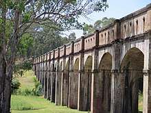
Originally it was a water canal once used to transport water from the Prospect Reservoir, but has since been decommissioned and converted into a cycle and walkway. Despite this, it is still referred to by its original function. The Canal features the regionally well-known Boothtown Aqueduct (as its original function was) located on Macquarie Rd, Greystanes.
The south-west of Greystanes contains the Gipps Road Sporting Complex and the Rosford Street Reserve, which consist of multiple ovals suitable for sports such as football and cricket. Around the ovals are large, open fields, suitable for other forms of recreation and a small BMX track in Rosford Street Reserve. A small-bore rifle club is located on Hyland Road, near the aforementioned sporting complexes and the Hyland Road Youth Centre. The Cumberland Country Golf Club is located to the geographic centre of the suburb.
Population
Demographics
According to the 2016 census there were 22,802 residents in Greystanes. Of these:
- 49.2% were male and 50.8% were female
- The median age was 38 years, the same as the national median . Children aged 0–14 years made up 20.7% of the population and people aged 65 years and over made up 18.0% of the population.
- 63.7% of people were born in Australia. The most common countries of birth were Lebanon 3.6%, Malta 3.0%, India 2.5%, China 1.6% and New Zealand 1.4%..
- The most common ancestries were Australian 18.5%, English 14.9%, Lebanese 9.9%, Maltese 5.6% and Irish 5.6%.
- 58.6% of people only spoke English at home. Other languages spoken at home included Arabic 10.4%, Maltese 3.1%, Greek 2.2%, Italian 2.1% and Turkish 1.5%.
- The most common responses for religion were Catholic 46.4%, No Religion 11.6%, Anglican 9.9%, Not Stated 6.0% and Islam 5.7%.
- The most common occupations in Greystanes were Clerical and Administrative Workers 19.3%, Professionals 18.6%, Technicians and Trades Workers 14.4%, Managers 11.4%, and Sales Workers 10.4%.[1]
Politics
Greystanes is within the local government area of Cumberland Council, with Viv May appointed as Administrator until elections in September 2017.[8] At the state level, Hugh McDermott (Labor) is the State MP for Prospect and Julia Finn (Labor) is the State MP for Granville. At the federal level, Chris Bowen (Labor) is the Federal MP for McMahon.
References
- Australian Bureau of Statistics (27 June 2017). "Greystanes (State Suburb)". 2016 Census QuickStats. Retrieved 14 February 2019.


- "Greystanes (suburb)". Geographical Names Register (GNR) of NSW. Geographical Names Board of New South Wales. Retrieved 20 January 2015.
- The Book of Sydney Suburbs, Compiled by Frances Pollon, Angus & Robertson Publishers, 1990, Published in Australia ISBN 0-207-14495-8, page 116
- "Google Translate". translate.google.com.au.
- "Lower Prospect Canal Reserve". New South Wales State Heritage Register. Office of Environment and Heritage. H01945. Retrieved 18 May 2018.
- Statistics, c=AU; o=Commonwealth of Australia; ou=Australian Bureau of. "Redirect to Census data page".
- http://www.republicast.com/publications/ebab8e322f6f4f379ee3203447e69eeb/default.htm#p=80&c=0&v=1/ SCA Announcement, December 2013
- "Cumberland Council". www.strongercouncils.nsw.gov.au.