Great Totham
Great Totham is a large parish village in Maldon district, Essex, England situated midway between Chelmsford and Colchester. The village includes the Island of Osea in the Blackwater estuary and is separated into two parts, north and south. The north side and the south side which are about a mile and a half apart distributed along the B1022.[2]
| Great Totham | |
|---|---|
 Great Totham | |
 Great Totham Location within Essex | |
| Population | 2,930 (2011)[1] |
| OS grid reference | TL862122 |
| Civil parish |
|
| District |
|
| Shire county | |
| Region | |
| Country | England |
| Sovereign state | United Kingdom |
| Post town | Maldon |
| Postcode district | CM9 |
| Dialling code | 01621 |
| Police | Essex |
| Fire | Essex |
| Ambulance | East of England |
| UK Parliament | |
| Website | Great Totham online |
History of the village
According to the old maps, before the time of the enclosures, the outskirts of Great Totham North were part of Tiptree Heath, which was then well known as a haunt of smugglers, this being celebrated in the name of a house in Mountains Road called Spirits Hall. The 'mountain' in question is Beacon Hill which at 83 metres is one of the highest points in the county and probably the original place of settlement, giving the name Totham. This possibly derived from the Saxon, meaning look out or hill top dwelling.[3]
South of the village of Great Totham is St Peter's church which dates back to the Norman times. There is also the Barn Chapel, with its thatched roof. This became a chapel back in 1822 when Mr Isaac Foster donated the barn to be a place of worship for non-conformists.[3]
The ancient road to Colchester by Tiptree Heath led through the parish of Great Totham, all of which in the reign of Queen Elizabeth I (1558-1603) was held of the Queen’s manor of East Greenwich by William Beriff, an Alderman of Colchester, as her sub-tenant.[4]
Great Totham village school celebrated its centenary in 1977, but by that time the Victorian building now demolished, had been replaced by a larger modern school situated on a different site. There is also a Grade II listed building known as the Honeywood School, this is a church school which was founded by the Honeywood family of Marks Hall, Coggeshall in the mid 19th century, who had inherited the manor of Great Totham. This is still in use as the church hall and meeting room.[3]
In the north of Great Totham there is a United Reformed church dating back to 1871. This has been recently refurbished and used not only for services but for many other activities such as the pre-school playgroup. Just around the corner adjoining the small village green, is the Compasses public house which dates back to the late 17th century.[3]
The Prince of Wales in Totham South was completely gutted by fire in 1990, so many historic features have been lost for ever, but it has been rebuilt and reopened, the first pint pulled by Ted Newton, who was born over 80 years ago.[3]
Great Totham has changed a great deal over the centuries, some of the crafts and trades having died out or been brought up to date. There are no longer any walking-stick makers, brickworks or saddlers. The old gravel pits have also become recreation areas for fishing lakes.[3]

Great Totham has a village sign. A plaque attached to the village sign of the north area reads:
On 17 October 1952, two Gloster Meteors of No 72 Squadron, Royal Air Force, crashed nearby killing both pilots. F/O Charles Muldownie from Rotherham and P/O Ian Carmichael from Devon. Two local people were injured and many were affected by the accident.
Local people assisted at the time and this village green became the base for recovery operations by RAF personnel. This plaque is in memory of the pilots and for all those involved.
- Dated October 2002.[5]
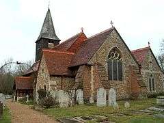
St Peter's Church
St Peter's Church, on Church Road in Great Totham, is a Grade II listed building dating from the 13th century. The church became a listed building in 1959.
School
Great Totham Primary School is located in Walden House Road, Great Totham. The school is divided into 14 classes, two per year group. The school's motto is "Enjoy, Respect, Achieve".[6] In its Ofsted inspection in October 2007, the school received an overall score of "2" which is graded as "Good".[7]
England cricketer Alastair Cook was a pupil at the school.
GirlGuiding in Great Totham
The Witham South District of GirlGuiding UK is made up of two Rainbow packs for girls aged 5–7 years old, three Brownie packs for girls aged 7–10 years old, a Guide unit for girls aged 10–14 years old and a Ranger unit for girls aged 14+ that live in Wickham Bishops, Great Totham and the surrounding villages.
Governance
There are several elected representatives at different levels of government which act for Great Totham and the surrounding villages.[8] Two elected district councillors represent Great Totham at Maldon District Council.
The current MP who represents the area (Witham) in the House of Commons is Priti Patel (Conservative).[8]
The population of the ward mentioned above was 3,660 at the 2011 Census.[9]
Public transport
Railway The closest National Rail service is located in Witham or Hatfield Peverel, and is operated by Abellio Greater Anglia. Destinations served from these stations include London Liverpool Street and Ipswich, Clacton, Harwich, Braintree and Norwich via the Great Eastern Main Line.[10] The nearest London Underground line is the Central line at Newbury Park.[11]
Healthcare
The nearest NHS (National Health Service) hospitals are Broomfield Hospital in Chelmsford[12] and Colchester General, Colchester.[13]
Climate
In East Anglia, the warmest time of the year is July and August, when maximum temperatures average around 21 °C (70 °F). The coolest time of the year is January and February, when minimum temperatures average around 1 °C (34 °F) East Anglia's average annual rainfall is about 605 millimetres , with October to January being the wettest months.
| Climate data for East Anglia (1971–2000 averages) | |||||||||||||
|---|---|---|---|---|---|---|---|---|---|---|---|---|---|
| Month | Jan | Feb | Mar | Apr | May | Jun | Jul | Aug | Sep | Oct | Nov | Dec | Year |
| Average high °C (°F) | 6.7 (44.1) |
7.1 (44.8) |
9.9 (49.8) |
12.3 (54.1) |
16.1 (61.0) |
19.0 (66.2) |
21.8 (71.2) |
21.9 (71.4) |
18.6 (65.5) |
14.4 (57.9) |
9.8 (49.6) |
7.6 (45.7) |
13.8 (56.8) |
| Average low °C (°F) | 1.1 (34.0) |
0.9 (33.6) |
2.6 (36.7) |
3.9 (39.0) |
6.7 (44.1) |
9.6 (49.3) |
11.8 (53.2) |
11.8 (53.2) |
9.9 (49.8) |
7.0 (44.6) |
3.6 (38.5) |
2.1 (35.8) |
6.0 (42.8) |
| Average rainfall mm (inches) | 53.4 (2.10) |
37.2 (1.46) |
44.8 (1.76) |
45.3 (1.78) |
44.8 (1.76) |
54.3 (2.14) |
46.0 (1.81) |
50.1 (1.97) |
55.6 (2.19) |
59.0 (2.32) |
58.5 (2.30) |
56.8 (2.24) |
605.8 (23.85) |
| Source: Met Office | |||||||||||||
References
- "Parish population 2011". Retrieved 22 September 2015.
- (TL862122)
- ISBN 978-1-85306-685-6, The Essex Village Book, The Essex Village Book, accessed 24 May 2012
- England’s Gazetteer - An Accurate Description of All the Cities, Towns, and Villages of the Kingdom, vol.ii, London, date unclear but circa 1590. Under page “TO”.
- http://commons.wikimedia.org/wiki/File:Sign_plaque.jpg
- , Great Totham Primary, accessed 24 May 2012
- Ofsted Report, Current Ofsted Report, accessed 24 May 2012
- Great Totham find your local MP, WriteToThem, accessed 10 May 2012
- "Ward population 2011". Retrieved 22 September 2015.
- Greater Anglia, Greater Anglia Website, accessed 10 May 2012
- , Transport for London Website, accessed 10 May 2012
- Broomfield Hospital, Mid Essex Hospital Services NHS Trust. Retrieved 15 January 2019.
- Colchester General Archived 23 December 2011 at the Wayback Machine, Colchester Hospital University NHS Website, accessed 10 May 2012
- Met Office Archived 29 September 2007 at the Wayback Machine, Met Office Climate Data,accessed 10 May 2012
External links
![]()
| Authority control |
|
|---|