Great Nicobar Island
Great Nicobar is the southernmost and largest of the Nicobar Islands of India, north of Sumatra.
| Native name: Tokieong Long | |
|---|---|
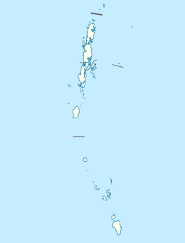 Great Nicobar Location of Great Nicobar Island in the Andaman and Nicobar Islands 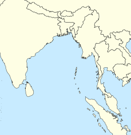 Great Nicobar Great Nicobar (Bay of Bengal) | |
| Geography | |
| Location | Bay of Bengal |
| Coordinates | 7.03°N 93.8°E |
| Archipelago | Nicobar Islands |
| Adjacent bodies of water | Indian Ocean |
| Total islands | 1 |
| Major islands |
|
| Area | 921 km2 (356 sq mi)[1] |
| Coastline | 202 km (125.5 mi) |
| Highest elevation | 642 m (2,106 ft) |
| Highest point | Mount Thullier |
| Administration | |
| District | Nicobar |
| Island group | Nicobar Islands |
| Subdivisions of India | Great Nicobar Subdivision |
| Taluk | Split between Little Nicobar and Campbell Bay Taluk |
| Largest settlement | Campbell Bay (pop. 5740) |
| Demographics | |
| Population | 8067 (2014) |
| Pop. density | 8.8/km2 (22.8/sq mi) |
| Ethnic groups | Hindustani, punjabi, Nicobarese shompen, malay |
| Additional information | |
| Time zone | |
| PIN | 744301 |
| Area code(s) | 03192 |
| ISO code | IN-AN-00[2] |
| Official website | www |
| Literacy | 84.4% |
| Avg. summer temperature | 32.0 °C (89.6 °F) |
| Avg. winter temperature | 28.0 °C (82.4 °F) |
| Sex ratio | ♂/♀ |
| Census Code | 35.638.0002 |
| Official Languages | Punjabi, English, Tamil Car (regional) |
History
In the 15th century, Great Nicobar Island was recorded as "Cui Lan island" (翠蘭嶼) during the voyages of Zheng He in the Mao Kun map of the Wu Bei Zhi.[3]
Great Nicobar island was severely affected by the 2004 Indian Ocean earthquake tsunami with many deaths, and was cut off from all outside contact for more than a day.
Geography
The island of Sumatra is located 180 km (110 mi) to the south of Great Nicobar. The island covers 921 km2 (356 sq mi) but is sparsely inhabited, with a population of 8067, largely being covered by rainforest and known for its diverse wildlife.
Demography
The island is home to the Great Nicobar Biosphere Reserve, Indira Point – the southernmost point of India and INS Baaz naval air station near Campbell Bay under the joint-services Andaman and Nicobar Command (ANC) of the Indian Armed Forces.[4] It is the southernmost air station of the Indian Armed Forces.[5]
The island is home to the Shompen people.[6]
Topography
The island has several rivers, including the Alexandra, Amrit Kaur, Dogmar and Galathea. Virtually all rivers flow in a southern or southwesterly direction, which is indicative of the general slope of the terrain across the island. There are undulating hills throughout the island, with the main range running in a north-south orientation. Mount Thullier, which is part of this range, has the highest elevation of any point in the Nicobars, at 642 m above sea level.[7]
Indira Point (6°45’10″N and 93°49’36″E) is the southernmost point of the Great Nicobar Island and India itself. Indira Point subsided 4.25 m in the 26 December 2004 tsunami and the lighthouse there was damaged. The lighthouse was subsequently made functional.
Fauna
The majority of the island is designated as the Great Nicobar Biosphere Reserve— home to many unique and endemic species of plants and animals including the Nicobar scrubfowl (Megapodius nicobariensis, a megapode bird), the edible-nest swiftlet (Aerodramus fuciphagus), the Nicobar long-tailed macaque (Macaca fascicularis umbrosa), saltwater crocodile (Crocodylus porosus), giant leatherback sea turtle (Dermochelys coriacea), Malayan box turtle, Nicobar tree shrew, reticulated python (Python reticulatus) and the giant robber crab (or coconut crab, Birgus latro).
Transportation
There is a 915m airstrip at Campbell Bay/Tenlaa on the East coast.[8][9]
- Seaport: At least one small shipping dock is located in Campbell Bay.
Indira Point
Indira Point is the name of the southernmost point of Republic of India. It is situated on Great Nicobar Island in the Nicobar Islands, which are located in the eastern Indian Ocean at 6°45’10″N and 93°49’36″E. This is not on the Indian mainland, but within the Union Territory of Andaman and Nicobar Islands. The name of the point was changed from Pygmalion Point on 18 October 1985[10] in commemoration of Indira Gandhi. It was formerly known by various names that include Pygmalion Point, Parsons Point, and for a brief period India Point.[11]
It is located 540 km and more than a day's sea voyage from Port Blair,[12] the capital city and main port of the Andaman and Nicobar Islands. It is approximately 163 km by sea from Sumatra, Indonesia.[11] Rondo Island, Indonesia's northernmost island in Sabang district of Aceh province of Sumatra, lies south of Indira point.[13] India and Indonesia are planning to collaborate to construct a port at Sabang to protect the channel between Great Nicobar Island and Rondo Island (c. May 2019).[14]
Indira Point lighthouse
Indira Point has a 35 m high cast iron (with red and white bands) lighthouse with 16 nautical miles range. The lighthouse has (RACON (Code 'G') ii DGPS station) with a 300 mm 4 panel revolving light inside a 2.5 m diameter lantern house (BBT). It is an important landmark on the international shipping lane Colombo-Singapore route via Malacca Strait that passes south of Indira Point. It also has a helipad.[15]
2004 tsunami
The tsunami which resulted from the Indian Ocean earthquake of 2004 inundated much of the area. This partly damaged the lighthouse, which subsided 4.25 m.[16] As a result of this subsidence, the coast retreated and the sea moved permanently inland. The lighthouse has since been repaired.[17]
The base of the lighthouse was 5 m above sea level when constructed in 1972. After the tsunami, the sea rose and the base was less than a metre above the sea level, showing over 4 meters of sea floor subsidence. It has been observed that the sea is slowly retreating back to its original position and the subsidence has decreased as the ocean floor slowly bounces back partially, a similar drop and rise due to crustal decompression and re compression was observed in the 2011 Tōhoku earthquake and tsunami on Honshu. Indira point was mostly submerged.
Image gallery
 Map
Map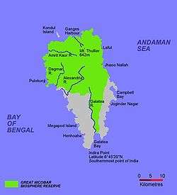 Map of Great Nicobar Island
 Locator
References
- "Islandwise Area and Population – 2011 Census" (PDF). Government of Andaman.
- Registration Plate Numbers added to ISO Code
- "Wu Bei Zhi Map 17". Library of Congress.
- "Naval air station opened in Campbell Bay". The Hindu. 31 July 2012.
- "INS Baaz to keep hawk eye on threats in Indian Ocean Region". The Times of India. 1 August 2012.
- Trivedi, Rajni; Sitalaximi, T.; Banerjee, Jheelam; Singh, Anamika; Sircar, P. K.; Kashyap, V. K. (March 2006). "Molecular insights into the origins of the Shompen, a declining population of the Nicobar archipelago". Journal of Human Genetics. 51 (3): 217–226. doi:10.1007/s10038-005-0349-2. PMID 16453062.
- Shyam Singh Shashi (2005), Encyclopaedia of Indian Tribes, Anmol Publications Pvt Ltd, ISBN 81-7041-836-4,
... The main hill range runs from the north to south. Average height of the hills is 300m to 400m. The highest peak is Mount Thullier ...
- "Missing Malaysia Airlines MH370 'Deliberately Diverted' Towards Andaman and Nicobar Islands: List of Unused Airports Where the Plane Possibly Landed [Photos]".
- "Runways – Campbell Bay Airport Campbell Bay, Andaman and Nicobar Islands, India".
- "Memories of Andaman and Nicobar Island on 18th October". Archived from the original on 2 February 2014. Retrieved 29 January 2014.
- Gupta, K.R.; Gupta, Amita. Concise Encyclopaedia of India. p. 1209. ISBN 81-269-0640-5.
- Sharma, A.N. Tribal Development in Andaman Islands. p. 6. ISBN 81-7625-347-2.
- "Rondo Island, The Rich Uninhabited Island". Archived from the original on 3 November 2012. Retrieved 19 May 2018.
- India seeks to aid Indonesia in developing port in Aceh, Economic Times, 19 May 2018.
- "Welcome to INDIRA POINT LIGHT HOUSE". Directorate General of Lighthouses and Lightships. Archived from the original on 3 March 2013. Retrieved 26 December 2012.
- Bilham, Roger. "Indira Point Lighthouse Subsidence 2004–2005".
- "Defunct Indira Point Lighthouse RACON repaired". oneindia.in. Retrieved 26 December 2012.
| Wikimedia Commons has media related to Great Nicobar. |