Grade I listed buildings in Tunbridge Wells (borough)
There are over 9,000 Grade I listed buildings in England. This page is a list of these buildings in the district of Tunbridge Wells in Kent.
Tunbridge Wells
| Name | Location | Type | Completed [note 1] | Date designated | Grid ref.[note 2] Geo-coordinates |
Entry number [note 3] | Image |
|---|---|---|---|---|---|---|---|
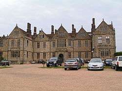
| Matfield House | Matfield, Brenchley, Tunbridge Wells | House | Dated 1738 | 20 October 1954 | TQ6581541928 51°09′09″N 0°22′10″E |
1250644 | |
| Stable Block immediately North East of Matfield House | Matfield, Brenchley | Stable | 1736 on clock | 20 October 1954 | TQ6583541943 51°09′10″N 0°22′11″E |
1250646 |  Stable Block immediately North East of Matfield House |
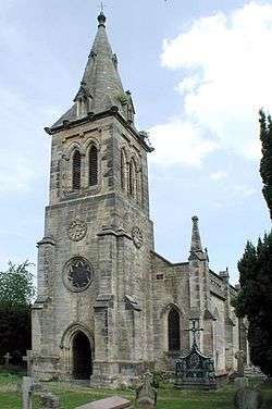
| Parish Church of All Saints | Brenchley | Parish Church | Evidence of pre 13th century masonry | 20 October 1954 | TQ6796941708 51°09′00″N 0°24′01″E |
1249609 | 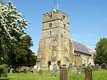 Parish Church of All Saints |
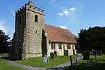
| Church of All Saints | Capel | Church | 'Lately rebuilt' in 1798 | 20 October 1954 | TQ6215645407 51°11′06″N 0°19′08″E |
1261437 | 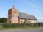 Church of All Saints |
| Church of St Thomas à Becket | Capel | Parish Church | Norman origins | 20 October 1954 | TQ6373444513 51°10′35″N 0°20′28″E |
1262867 | |
| Somerhill | Somerhill Park, Capel | School | 1954 | 20 October 1954 | TQ6086745121 51°10′58″N 0°18′01″E |
1253489 | |
| Barn 60 Yards North of the West Range of Sissinghurst Castle | Sissinghurst, Cranbrook | Barn | Early 16th century | 20 June 1967 | TQ8078138392 51°06′59″N 0°34′54″E |
1099119 | 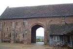 Barn 60 Yards North of the West Range of Sissinghurst Castle |
| Church of St Dunstan | Cranbrook | Obelisk | 1736 | 20 June 1967 | TQ7768936169 51°05′50″N 0°32′11″E |
1099931 | 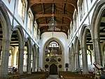 Church of St Dunstan |
| Cranbrook or Union Windmill | Cranbrook | Smock Mill | 1814 | 9 June 1952 | TQ7790635948 51°05′43″N 0°32′21″E |
1356175 | |
| Old Wilsley | Wilsley Green, Cranbrook | Kitchen | Former | 9 June 1952 | TQ7796336997 51°06′17″N 0°32′26″E |
1338663 |  |
| Tower and Walls 30 Yards East of the West Range at Sissinghurst Castle | Sissinghurst, Cranbrook | Tower | c. 1570 | 9 June 1952 | TQ8080538315 51°06′56″N 0°34′55″E |
1084163 | 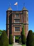 Tower and Walls 30 Yards East of the West Range at Sissinghurst Castle |
| West Range at Sissinghurst Castle | Sissinghurst, Cranbrook | Apartment | 1986 | 9 June 1952 | TQ8077638324 51°06′56″N 0°34′53″E |
1346285 | .JPG) West Range at Sissinghurst Castle |
| Christ Church | Kilndown, Goudhurst | Parish Church | 1839-41 | 26 September 1980 | TQ7006035187 51°05′27″N 0°25′37″E |
1338690 | |
| Church of St Mary | Goudhurst | Parish Church | 13th century to 15th century | 20 June 1967 | TQ7239437810 51°06′49″N 0°27′42″E |
1338671 | |
| Finchcocks | Finchcocks, Goudhurst | House | dated 1725 | 9 June 1952 | TQ7003836460 51°06′08″N 0°25′38″E |
1318935 | |
| Church of St Laurence | Hawkhurst | Cross | 1917 | 20 June 1967 | TQ7559629449 51°02′15″N 0°30′11″E |
1120819 |  Church of St Laurence |
| Church of St Margaret | Horsmonden | Parish Church | 14th century | 20 October 1954 | TQ7038338112 51°07′01″N 0°25′59″E |
1087022 | 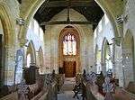 Church of St Margaret |
| Church of St Mary | Lamberhurst | Parish Church | 12th century | 20 October 1954 | TQ6820736580 51°06′14″N 0°24′04″E |
1084519 | 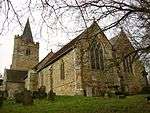 Church of St Mary |
| Scotney Castle with Courtyards and Garden Terrace | Lamberhurst | House | 1837-44 | 20 October 1954 | TQ6873435373 51°05′34″N 0°24′29″E |
1336699 | 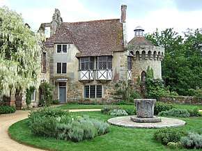 Scotney Castle with Courtyards and Garden Terrace |
| The Ruins of Old Scotney Castle | Scotney, Lamberhurst | Castle | 1378 | 20 October 1954 | TQ6896835229 51°05′29″N 0°24′41″E |
1085287 | 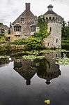 The Ruins of Old Scotney Castle |
| Old Church of St Peter | Pembury | Parish Church | Norman | 20 October 1954 | TQ6260442979 51°09′47″N 0°19′27″E |
1254444 | 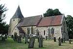 Old Church of St Peter |
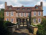
| Buildings of the Service Courtyard Adjoining South of Groombridge Place Including the Walls of the Herb Garden | Old Groombridge, Speldhurst | House | c. 1660 | 20 October 1954 | TQ5335637592 51°07′02″N 0°11′23″E |
1260883 | |
| Chapel of St John the Evangelist | Old Groombridge, Speldhurst | Chapel of Ease | 1625 | 20 October 1954 | TQ5306537682 51°07′05″N 0°11′08″E |
1240708 | .JPG) Chapel of St John the Evangelist |
| Church of St Martin of Tours | Ashurst, Speldhurst | Church | 14th century | 20 October 1954 | TQ5117339037 51°07′50″N 0°09′33″E |
1074896 |  Church of St Martin of Tours |
| Garden Walls and Features of the Terraced Garden (including Ivy Cottage) approx. 30 Metres North of Groombridge Place | Old Groombridge, Speldhurst | House | c. 1980 | 20 October 1954 | TQ5328437681 51°07′05″N 0°11′19″E |
1240706 | |
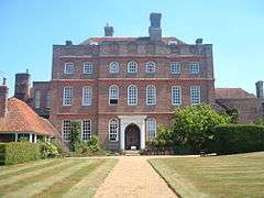
| Groombridge Place | Old Groombridge, Speldhurst | Country House | Between 1652 and 1674 | 20 October 1954 | TQ5334137619 51°07′02″N 0°11′22″E |
1260959 | |
| Groombridge Place Moat, Walls and Bridge including the West Gateway and Cottage on the North Bridge | Old Groombridge, Speldhurst | House | Second half of 17th century | 20 October 1954 | TQ5322937625 51°07′03″N 0°11′16″E |
1260960 | 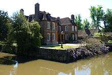 Groombridge Place Moat, Walls and Bridge including the West Gateway and Cottage on the North Bridge |
| The Church of King Charles the Martyr | Tunbridge Wells | Church | 1676-1684 | 20 May 1952 | TQ5819738810 51°07′36″N 0°15′34″E |
1084478 |


Notes
- The date given is the date used by Historic England as significant for the initial building or that of an important part in the structure's description.
- Sometimes known as OSGB36, the grid reference is based on the British national grid reference system used by the Ordnance Survey.
- The "List Entry Number" is a unique number assigned to each listed building and scheduled monument by Historic England.
External links
![]()
This article is issued from Wikipedia. The text is licensed under Creative Commons - Attribution - Sharealike. Additional terms may apply for the media files.