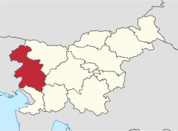
Gorizia Statistical Region
The Gorizia Statistical Region[1][2][3][4][5] (Slovene: Goriška statistična regija) is a statistical region in western Slovenia, along the border with Italy. It is named after the Italian town of Gorizia (the feminine adjective goriška comes from the Slovenian name for Gorizia: Gorica).[6][7] The Julian Alps, the Soča River, and the Vipava Valley are the most prominent natural features of this region. It contributed just over 5% to total national GDP in 2012, but in terms of GDP per capita it ranked fourth in the country. In the same year, disposable income per capita in the region the highest, in second place behind the Central Slovenia Statistical Region. Housing stock estimates indicate that at the end of 2013 the region had the highest share of dwellings with three or more rooms (around 70%). The share of single-room dwellings was less than 10%. Dwellings here are larger than the Slovenian average, with 37 m² of usable floor space per person on average. The number of cars per 1,000 population is also the highest in Slovenia, with an average of 100 cars more per 1,000 people than in the Central Sava Statistical Region. However, the cars here and in the Lower Sava Statistical Region are also the oldest (on average almost 10 years old in 2013).
Gorizia Statistical Region Goriška statistična regija | |
|---|---|
 | |
| Municipalities | 13 |
| Largest city | Nova Gorica |
| Area | |
| • Total | 2,325 km2 (898 sq mi) |
| Population (2020) | |
| • Total | 118,041 |
| • Density | 51/km2 (130/sq mi) |
| Statistics | |
| • Households | 46255 |
| • Employed | 39307 |
| • Registered unemployed | 5722 |
| • College/university students | 5136 |
| • Regional GDP: | EUR 1.937 bn (EUR 16,371 per capita) |
Municipalities
The Gorizia Statistical Region comprises the following municipalities:
- Ajdovščina
- Bovec
- Brda
- Cerkno
- Idrija
- Kanal
- Kobarid
- Miren-Kostanjevica
- Nova Gorica
- Renče-Vogrsko
- Šempeter-Vrtojba
- Tolmin
- Vipava
Demographics
The population in 2020 was 118,041. It has a total area of 2,325 km².
Economy
Employment structure: 59% services, 37.8% industry, 3.2% agriculture.
Tourism
It attracts 9.8% of the total number of tourists in Slovenia, most being from Italy (41.5%) and Slovenia (20.7%).
Transportation
- Length of motorways: 44.8 km
- Length of other roads: 3,149 km
Sources
- Dermol, Valerij et al. 2013. Connecting Research, Higher Education and Business: Implications for Innovation. IJEMS 6(1): 65–80, pp. 71ff.
- Lešnik, Sabina. 2013. Učenje tujih jezikov z vidika staršev iz različnih slovenskih regij. Revija za elementarno izobraževanje 6(2–3): 31–46, p. 32.
- Lešnik, Sabina. 2014. The Role of Socio-Cultural Environment in Foreign Language Learning. Dissertation. Maribor: University of Maribor.
- Urlep, Darja, Rok Blagus, & Rok Orel. 2015. Incidence Trends and Geographical Variability of Pediatric Inflammatory Bowel Disease in Slovenia: A Nationwide Study. BioMed Research International. Online publication (November 24), pp. 2, 5.
- Lapuh, Lucija. 2016. Measuring the Impact of the Recession on Slovenian Statistical Regions and Their Ability to Recover. Acta geographica Slovenica 56(2): 247–256, pp. 252ff.
- Snoj, Marko. 2009. Etimološki slovar slovenskih zemljepisnih imen. Ljubljana: Modrijan and Založba ZRC, p. 144.
- Merkù, Pavle. 1999. Slovenska krajevna imena v Italiji. Priročnik. Trieste: Mladika, p. 33.