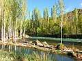
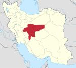
Golpayegan
Golpayegan (Persian: گلپایگان, romanized: Golpāyegān; also known as Shahr-e Golpāyegān meaning "City of Golpayegan")[2] is a city and capital of Golpayegan County, Isfahan Province, Iran. At the 2006 census, its population was 47,849, in 14,263 families.[3] Golpayegan is located 186 kilometres (116 mi) northwest of Isfahan and 102 kilometres (63 mi) southeast of Arak, situated at an altitude of 1,830 m. Its temperature fluctuates between +37° and -10° Celsius. Its average annual rainfall is 300 mm.[4]
Golpayegan گلپایگان | |
|---|---|
City | |
 Golpayegan | |
| Coordinates: 33°27′13″N 50°17′18″E | |
| Country | |
| Province | Isfahan |
| County | Golpayegan |
| Bakhsh | Central |
| Elevation | 1,830 m (6,000 ft) |
| Population (2016 Census) | |
| • Total | 58,936[1] |
| Time zone | UTC+3:30 (IRST) |
| • Summer (DST) | UTC+4:30 (IRDT) |
| Area code(s) | 031 |
| Website | http://www.akhale.ir/ (in Persian:آخاله |
Land of tulips
Historically, the name of the town has been recorded as Vartpadegān,[5] Jorfadeghan,[6] Darbayagan, Kuhpayegan,[7] and Golbādagān.[8] Golpayegan means "fortress of flowers" and "land of tulips" (Persian: سرزمین گلهای سرخ, romanized: Sarzamin-e golha-ye sorkh). According to Ḥamd-Allāh Mostawfi, the town of Golpāyegān was built by the daughter of Bahman, named Samra, also known as Homāy Bente Bahman in Persian.[9]
History
After Parsadan Gorgijanidze was dismissed from his post as prefect (darugheh) of Isfahan, he was appointed as the new eshik-agha (Master of Ceremonies) and given five villages in the confines of Golpayegan as a fief by king (shah) Abbas II (r. 1642-1666).[10][11] Historically, the name of the town has been recorded as Karbāyagān; Jarbāḏaqān; Darbāyagān; and Golbādagān.[12]
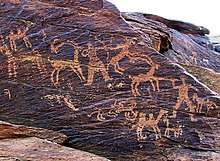
Historical monuments
Several historical monuments are located in Golpayegan: Jameh mosque of Golpayegan, a minaret (Manar) from the Seljuk period, the Sarāvar mosque from the 15th-16th centuries, as well as the Hevdah Tan shrine from the 17th century[13], Gouged Stronghold, the stronghold was used as a caravansary, but during the war time or when the bandits attacked, it was used as a castle.
Gallery
References
- https://www.amar.org.ir/english
- Golpayegan can be found at GEOnet Names Server, at this link, by opening the Advanced Search box, entering "-3064684" in the "Unique Feature Id" form, and clicking on "Search Database".
- "Census of the Islamic Republic of Iran, 1385 (2006)". Islamic Republic of Iran. Archived from the original (Excel) on 2011-11-11.
- (Wezārat-e defāʿ, pp. 218-19; Wezārat-e rāh wa tarābari, pp. 119-20).
- (Eṣṭaḵri, p. 198, n. c);
- Moqaddasi, p. 402;
- (Abu’l-Fedā, Taqwim, p. 419;
- (Nozhat al-qolub, ed. Le Strange, p. 68).
- (p. 95) and Qāżi Aḥmad Ḡaffāri (p. 30),
- Giunashvili 2016.
- Paghava, Turkia & Akopyan 2010, p. 22.
- Minu Yusofnezhad, "GOLPĀYAGĀN", Encyclopaedia Iranica
- (Meškāti, pp. 64-67; Rafiʿi Mehrābādi, pp. 895-96, 898-901).
.jpg)
Sources
- Giunashvili, Jemshid (2016). "GORGIJANIDZE, PARSADAN". Encyclopaedia Iranica.CS1 maint: ref=harv (link)
- Paghava, I., Turkia S., Akopyan A. (2010), "The cross-in-circle mark on the silver coins of the Safavid ruler, Sultān Husayn, from the Iravān mint", Journal of the Oriental Numismatic Society 202
External links
| Wikimedia Commons has media related to Golpayegan. |
- ' Hamneshine Bahar: Golpayegan (golpayegun) shahre lalehaye vajgun همنشین بهار: گلپایگان (گلپایکون)، شهر لالههای واژگون
- Golpayegan Dam
- Golpayegan Dam . map
- Hamneshine Bahar : Golpayegan (video)
- The News Golpayeganiha
- The News Golpapress
| Capital | |||||||||||||
|---|---|---|---|---|---|---|---|---|---|---|---|---|---|
| Districts |
| ||||||||||||