Goathland Bank Top railway station
Goathland Bank Top was a short lived, early, railway station in Goathland, North Yorkshire, England. The station at the top of the Beckhole Incline (sometimes referred to as the Goathland Incline) was opened with the opening throughout of the Whitby and Pickering Railway (W&P) on Thursday 26 May 1836.[1] The station closed with the opening of the NER's Deviation line (which bypassed the by then anachronistic cable worked incline) on 1 July 1865.[2] Thus the station had a life of less than thirty years. A new Goathland station (initially called Goathland Mill to distinguish it from the earlier station) was opened on the deviation line.[3]
| Goathland Bank Top | |
|---|---|
| Location | |
| Place | Goathland |
| Area | Scarborough |
| Coordinates | 54.402789°N 0.719715°W |
| Grid reference | NZ831015 |
| Operations | |
| Original company | Whitby and Pickering Railway |
| History | |
| 26 May 1836 | Opened |
| 1 July 1865 | Closed |
| Disused railway stations in the United Kingdom | |
| Closed railway stations in Britain A B C D–F G H–J K–L M–O P–R S T–V W–Z | |
Whitby and Pickering Railway (1836-45)
Little is known about what facilities the horse-worked W&P provided at Goathland, they did build an 'overseers cottage' at the head of the incline, that cottage survives, now known as 'Ash Tree Cottage', it is probably the only surviving inhabited W&P structure which is now a grade II listed building that passed into private ownership in 1913.[4]
The incline was built with a 1-in-15 gradient to the design of the W&P's Engineer George Stephenson and was self-acting with the descending traffic hauling up the ascending traffic.[5] The descending coach or wagons was given additional weight by means of a wheeled water butt, which was filled before descending, then drained at the bottom and returned to the top with the next ascending load.[6] The machinery for working the inclined plane was obtained from Robert Stephenson at a cost of £135 14s 6d. The original rope for the incline manufactured by Mr. Henry Simpson was 1,500 yards long and 5.5 inches in circumference.[7]
The W&P built a stable 'at the top of Goathland Inclined Plane', the directors accepting a tender from a Mr. Langdale of £230. The York & North Midland Railway (Y&NM) replaced the water gravity system with a stationary steam engine in 1846.[8]
What can be seen today
_station_site_today.jpg)
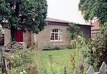
At a first glance the unattuned observer would hardly realise that there had been a railway, never mind a station on the site of Goathland's first station. However the presence of a 'Historic Rail Trail' following the original alignment gives away the one-time presence of a railway.[9] In the adjacent image the worn track on the grass roughly follows the track alignment. In the distance can be seen the Y&NM terrace (with three distinctive chimney stacks), one (modern) house beyond that stands 'Ash Tree Cottage', the W&P's cottage at the head of the incline.[10] The incline itself starts just out of sight, about where the path disappears.
References
- Suggitt, Gordon (2005). Lost railways of North and East Yorkshire. Newbury: Countryside Books. p. 86. ISBN 978-1-85306-918-5.
- Bairstow, Martin (2008). Railways around Whitby (3 ed.). Halifax: Martin Bairstow. p. 17. ISBN 978-1-871944-34-1.
- Burgess, Neil (2011). The lost railways of Yorkshire's North Riding. Catrine: Stenlake. p. 21. ISBN 9781840335552.
- Historic England. "Ash Tree Cottage, Goathland (Grade II) (1316176)". National Heritage List for England. Retrieved 31 December 2017.
- Haigh, A.; Joy, David (1979). Yorkshire railways : including Cleveland and Humberside. Clapham, N. Yorkshire: Dalesman. p. 6. ISBN 0-85206-553-1.
- Chapman, Stephen (2008). York to Scarborough, Whitby & Ryedale. Todmorden: Bellcode Books. p. 4. ISBN 9781871233193.
- Tomlinson, William Weaver (1915). The North Eastern Railway, its rise and development. London: Longmans & Co. p. 302. OCLC 854595777.
- Vanns, Michael (2017). "Early Days to Best Years". The North Yorkshire Moors Railway. Barnsley: Pen & Sword. p. 17. ISBN 9781473892088.
- "Walks". nymr.co.uk. Retrieved 31 December 2017.
- "Goathland Conservation Area Character Appraisal" (PDF). northyorkmoors.org.uk. November 2017. p. 72. Retrieved 31 December 2017.
- Belcher, Henry (1976). Illustrations of the scenery on the line of the Whitby and Pickering Railway in the north-eastern part of Yorkshire. East Ardsley, [Eng.]: EP Publishing. ISBN 0-7158-1164-9.
- Potter, G.W.J. (1969). A History of the Whitby and Pickering. SR Publishing. ISBN 0-85409-553-5.
- Whitby and Pickering Railway Company, Directors Minute Book. Whitby and Pickering Railway Company (The Nation Archives Ref. RAIL 742/1). 1833–1845.
| Preceding station | Disused railways | Following station | ||
|---|---|---|---|---|
| Levisham | Whitby and Pickering Railway | Beckhole |