Panhole
A panhole is a shallow depression or basin eroded into flat or gently sloping cohesive rock.[1] Confusingly, some authors[2] refer to panholes also as potholes, which is a term typically used for similarly shaped riverine landforms. Similar terms for this feature are gnamma (Australia), armchair hollows, weathering pans (or pits) and solution pans (or pits).[1][2]
In fluvial geomorphology, the term pothole is typically used for a smooth, bowl-shaped or cylindrical hollow, generally deeper than wide, found developed in the rocky bed of a stream. This type of feature is created by the grinding action either of a stone or stones or of coarse sediment whirled around and kept in motion by eddies or the force of the stream current in a given spot.[3]
Description of panholes
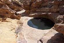
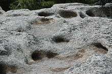
Panholes are erosional or destructional features that are developed in a variety of climatic environments and in a wide range of rock types. These shallow basins, or closed depressions, are quite commonly well developed in surfaces of granitic rocks and sandstone. They are generally characterized by flat bottoms and sometimes by overhanging sides. The initial form may be a closed hollow created by a patch of humus. Diameters are rarely greater than 15 cm (5.9 in). Some panholes were at one time thought to be man-made because their roundness was so perfect they were argued not be natural and must have been shaped by humans.[1][2]
Panholes are most commonly found in desert environments such as the Colorado Plateau. A few well-known panholes are found developed in sandstone surfaces in Canyonlands National Park, Capitol Reef National Park, and Moab. Panholes are capable of collecting water when it rains, freezing over when the weather gets cold, dry out in hotter weather, and can even contain some species of bacteria. Panholes range in size from a few centimeters to many meters in diameter. The cavities can be shallow or more than 15 meters (49 ft) deep, containing hundreds of liters of water. The Australian aboriginal term gnamma, in particular, implies a depression capable of holding water at times.[2]
Within the potholes is a varied eco-system that contains bacteria such as cyanobacteria, fungi, and algae which can be referred as biofilm.[2] Potholes do not contain predators like fish or aquatic insect.[4] The biofilm breaks down some of the siliceous minerals in the pothole for nutrients resulting in furthering the weathering the pothole.[4] The organisms that live in the potholes have to tolerate rapid change in water temperature, pH, oxygen, carbon dioxide concentration, and ion concentration.[2]
Origin of panholes
In the Sierra Nevada, California these features were termed weathering pits[5] by François E. Matthes, where they are thought to indicate rock surfaces that are unglaciated or escaped more recent glaciations. In Sierra Nevada granitic rocks, these features have a characteristic shape such that they expand more rapidly in width than they grow in depth. [6] One explanation for their conformation is because the most active environment for weathering is the zone of alternate wetting and drying along the margins of the pools that collect in the pits, the margins tend to deepen and enlarge until all points of the bottom are equally wet or dry at the same time, thus producing their characteristic shape. [7] Potholes can expand from weathering and erosion but the main activity of how potholes expand is from biological weathering. At one time the belief was that the only agents involved with the expansion of potholes were physical weathering.[2]
References
- Twidale, C.R., and Bourne, J.A., 2018. Rock basins (gnammas) revisited. Géomorphologie: relief, processus, environnement, Articles sous presse, Varia, mis en ligne le 08 janvier 2018, consulté le 01 juillet 2018.
- Hughes, Kebbi A., 2012. Bacterial Communities and their Influence on the Formation and Development of Potholes in Sandstone Surfaces of the Semi-Arid Colorado Plateau University of Western Ontario - Electronic Thesis and Dissertation Repository. Paper 543.
- Neuendorf, K.K.E., J.P. Mehl, Jr., and J.A. Jackson, eds., 2011. Glossary of Geology (5th ed.). Alexandria, Virginia, American Geological Institute. 800 pp. ISBN 0-922152-89-6
- Davis, Jim, 2013. "What are “Potholes” and how are organisms able to live in them?." Utah Geological Survey. N.p., n.d. Web. 9 Oct 2013.
- Matthes, Francois E. 1930. Geologic History of the Yosemite Valley. U.S. Geological Survey Professional Paper 160
- Huber, N. King. 1989. The geological story of Yosemite National Park. U.S. Geological Survey Bulletin 1595.
- Clyde Warhaftig, attributed on page p. 63 in Huber, N. King. 1989. The geological story of Yosemite National Park. U.S. Geological Survey Bulletin 1595.
Locations where panholes may be seen
- Beam Rocks, Forbes State Forest, Pennsylvania, USA
- Shenandoah National Park, Virginia, USA
- Glacier Point, Yosemite National Park, California, USA