Gmina Mińsk Mazowiecki
Gmina Mińsk Mazowiecki is a rural gmina (administrative district) in Mińsk County, Masovian Voivodeship, in east-central Poland. Its seat is the town of Mińsk Mazowiecki, although the town is not part of the territory of the gmina.
Gmina Mińsk Mazowiecki Mińsk Mazowiecki Commune | |
|---|---|
 Coat of arms | |
| Coordinates (Mińsk Mazowiecki): 52°11′N 21°34′E | |
| Country | |
| Voivodeship | Masovian |
| County | Mińsk |
| Seat | Mińsk Mazowiecki |
| Area | |
| • Total | 112.28 km2 (43.35 sq mi) |
| Population (2013[1]) | |
| • Total | 14,628 |
| • Density | 130/km2 (340/sq mi) |
| Website | http://www.minskmazowiecki.pl/ |
The gmina covers an area of 112.28 square kilometres (43.4 sq mi), and as of 2006 its total population is 12,876 (14,628 in 2013).
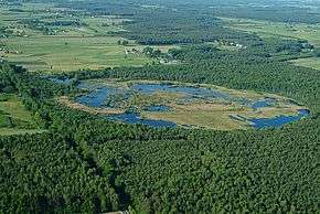
There is nature reserve called Marsh of Pogorzel, with drosera rotundifolia flowers..
Villages
Gmina Mińsk Mazowiecki contains the villages and settlements of Anielew, Arynów, Barcząca, Borek Miński, Brzóze, Budy Barcząckie, Budy Janowskie, Chmielew, Chochół, Cielechowizna, Dłużka, Dziękowizna, Gamratka, Gliniak, Grabina, Grębiszew, Huta Mińska, Ignaców, Iłówiec, Janów, Józefów, Karolina, Karolina-Kolonia, Kluki, Kolonia Janów, Królewiec, Maliszew, Marianka, Mikanów, Niedziałka Druga, Nowe Osiny, Osiny, Podrudzie, Prusy, Stara Niedziałka, Stare Zakole, Stojadła, Targówka, Tartak, Wólka Iłówiecka, Wólka Mińska, Zakole-Wiktorowo, Zamienie and Żuków.
Neighbouring gminas
Gmina Mińsk Mazowiecki is bordered by the town of Mińsk Mazowiecki and by the gminas of Cegłów, Dębe Wielkie, Jakubów, Kołbiel, Siennica, Stanisławów and Wiązowna.
References
| Urban gminas |
|  |
|---|---|---|
| Urban-rural gminas | ||
| Rural gminas | ||