Gmina Choroszcz
Gmina Choroszcz is an urban-rural gmina (administrative district) in Białystok County, Podlaskie Voivodeship, in north-eastern Poland. Its seat is the town of Choroszcz, which lies approximately 13 kilometres (8 mi) west of the regional capital Białystok.
Gmina Choroszcz Choroszcz Commune | |
|---|---|
 Flag  Coat of arms | |
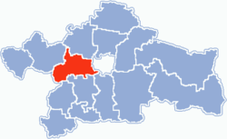 Location within Białystok County | |
| Coordinates (Choroszcz): 53°8′N 22°59′E | |
| Country | |
| Voivodeship | Podlaskie |
| County | Białystok County |
| Seat | Choroszcz |
| Area | |
| • Total | 163.5 km2 (63.1 sq mi) |
| Population (2011) | |
| • Total | |
| • Urban | 5,732 |
| • Rural | 8,395 |
| Website | http://www.choroszcz.pl |
The gmina covers an area of 163.5 square kilometres (63.1 sq mi), and as of 2011 its total population is 14,127 (out of which the population of Choroszcz amounts to 5,732, and the population of the rural part of the gmina is 8,395).
Villages
Apart from the town of Choroszcz, Gmina Choroszcz contains the villages and settlements of Babino, Barszczewo, Czaplino, Dzikie, Dzikie-Kolonia, Gajowniki, Gajowniki-Kolonia, Izbiszcze, Jeroniki, Klepacze, Kolonia Czaplino, Konowały, Kościuki, Krupniki, Kruszewo, Łyski, Mińce, Ogrodniki Barszczewskie, Oliszki, Pańki, Porosły, Porosły-Kolonia, Rogówek, Rogowo, Rogowo-Kolonia, Rogowo-Majątek, Ruszczany, Sienkiewicze, Sikorszczyzna, Śliwno, Turczyn, Zaczerlany, Zaczerlany-Kolonia, Złotoria, Złotoria-Kolonia, Złotoria-Podlesie, Żółtki and Żółtki-Kolonia.
Neighbouring gminas
Gmina Choroszcz is bordered by the city of Białystok and by the gminas of Dobrzyniewo Duże, Juchnowiec Kościelny, Kobylin-Borzymy, Łapy, Sokoły, Turośń Kościelna and Tykocin.
References
| Urban-rural gminas |  | |
|---|---|---|
| Rural gminas | ||
| Seat (not part of the county) | ||