Giza Plateau
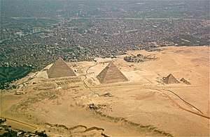
The Giza Plateau (Arabic: جيزة بلاتي) is a plateau in Giza, on the outskirts of Cairo, Egypt, site of the Fourth Dynasty Giza Necropolis, which includes the Great Pyramids of Khufu, Khafre and Menkaure, the Sphinx, several cemeteries, a workers' village and an industrial complex.
The plateau is elevated approximately 60 meters above sea-level.[1]
Modern history
Modern Giza is accessed by two main roads.[2] The road from the north leads to Khufu's pyramid; the other to near the Sphinx's front court, from the east. They cross the Nile River from the east bank and follow the causeway westward. Dominating the plateau and running in a southwest diagonal through the site are the three pyramids of the pharaohs Khufu, Khafra, and Menkaure.
Survey
The Giza Plateau Mapping Project (GPMP) was undertaken in 1984, "an effort to better understand the social and economic forces that supported pyramid construction."[3]
Mark Lehner and his team produced an accurate map of the natural and cultural features of the entire Giza Plateau. Survey data suggested to Lehner possible locations for the city of the pyramid builders, so in 1988 the mission of the GPMP was extended to excavate and survey those areas.[3]
External links
References
- "Elevation of Giza Plateau, Al Haram, Giza Governorate, Egypt". elevation.maplogs.com.
- Firestone, Matthew (2010). Egypt. The Lonely Planet. ISBN 9781742203324. Retrieved 1 November 2016.
- Mark Lehner. "Giza, Meter by Meter: High-precision measure of the landscape". aeraweb.org.
| City | 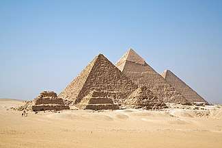 | |
|---|---|---|
| Abu Rawash | ||
| Giza | ||
| Abusir | ||
| Saqqara |
| |
| Dahshur | ||
| See also | ||