Gin Ganga
The Gin Ganga (Sinhala: ගිං ගඟ, Gin River), is a 115.9 km (72 mi) long river situated in Galle District of Sri Lanka.[1]
| Gin | |
|---|---|
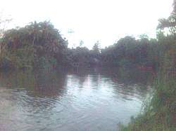 Gin Ganga at Deniyaya | |
 | |
| Native name | ගිං ගඟ (Gin Ganga) |
| Location | |
| Country | Sri Lanka |
| Physical characteristics | |
| Source | Sinharaja Forest Reserve |
| Mouth | Indian Ocean |
⁃ location | Gintota |
⁃ coordinates | 06°03′47″N 80°10′27″E |
| Length | 115.9 km (72.0 mi) |
| Basin features | |
| Tributaries | |
| ⁃ left | Nagare Ela, Divithura Ela |
| ⁃ right | Holuwagoda Ela |
| Bridges |
|
The river's headwaters are located in the Gongala Mountain range, near Deniyaya, bordering the Sinharaja Forest Reserve. The river flows past the villages of Baddegama, Nagoda, Thelikada and Hegoda. The Wakwella Bridge, which was the longest bridge in Sri Lanka, is built over this river. The river is also dammed at the Thelikada. The mouth of the river is at Gintota, just north of Galle.
See also
- List of rivers in Sri Lanka
- Wakwella Bridge
References
- Arumugam, Sanmugam (1969). Water Resources of Ceylon: Its Utilisation and Development. Water Resources Board. p. 74-76.
This article is issued from Wikipedia. The text is licensed under Creative Commons - Attribution - Sharealike. Additional terms may apply for the media files.