Gilwern Halt railway station
Gilwern Halt railway station was a station on the London and North Western Railway's Heads of the Valleys line near the village of Gilwern in the Welsh county of Brecknockshire.[1]
| Gilwern Halt | |
|---|---|
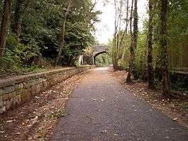 Station remains in 2006. | |
| Location | |
| Place | Gilwern |
| Area | Monmouthshire |
| Coordinates | 51.8189°N 3.0994°W |
| Grid reference | SO243139 |
| Operations | |
| Original company | Merthyr, Tredegar and Abergavenny Railway |
| Pre-grouping | London and North Western Railway |
| Post-grouping | London, Midland and Scottish Railway |
| Platforms | 2 |
| History | |
| c. February/March 1863 | Opened |
| c. 1932-33 | Became a halt |
| 6 January 1958 | Closed |
| Disused railway stations in the United Kingdom | |
| Closed railway stations in Britain A B C D–F G H–J K–L M–O P–R S T–V W–Z | |
History
The first section of the Merthyr, Tredegar and Abergavenny Railway from Abergavenny to Brynmawr was opened on 29 September 1862.[2] The line was leased and operated by the London and North Western Railway (L&NWR) which acquired the smaller railway company on 30 June 1866.[3][4] The L&NWR was itself amalgamated into the London, Midland and Scottish Railway in the 1923 Grouping.[5]
Gilwern first appeared in Bradshaw in April 1863, however the line's engineer, John Gardner, had reported on 27 January 1863 that it was due for completion in three or four weeks and on 6 August he confirmed that it had been open for five months which suggests the actual opening took place in late February or early March.[6] The station was situated in a cutting which was crossed by a road bridge at the western end of the station.[7] It was reached from the east on a 1 in 37 climb from Govilon with the line rising 150 feet (46 m) in less than 2 miles (3.2 km).[8] The station was conveniently situated for Gilwern village which was only 0.5 miles (0.80 km) away.[9] It was also convenient for the Brecknock and Abergavenny Canal and for this reason attracted a good summer passenger traffic as the Sunday schools in the area had afternoon outings to spend by the canal.[10]
It had two curved platforms with the Up platform higher than the Down as a result of the curvature.[11] A timber-built station building was situated on the Up platform while a wooden passenger shelter was provided on the Down platform.[12] Steps led upwards from the Down platform to the road bridge.[11] To the east was Gilwern Stone Quarry which was served by a siding branching off from the Down line.[7] The siding was controlled by a signal box which was in operation from 1890 to c. 1921 when the siding had been removed.[7] In c. 1932-33, the station was downgraded to a railway halt at around the same time as Trevil.[13]
Decline in local industry and the costs of working the line between Abergavenny and Merthyr led to the cessation of passenger services on 4 January 1958.[14][15] The last public service over the line was an SLS railtour on 5 January 1958 hauled by GWR 6959 No. 7912 Little Linford Hall and LNWR Coal Tank No. 58926.[14][16] Official closure came on 6 January.[6][17][18][19]
| Preceding station | Disused railways | Following station | ||
|---|---|---|---|---|
| Clydach Line and station closed |
London and North Western Railway Merthyr, Tredegar and Abergavenny Railway |
Govilon Line and station closed |
Present
The platforms have survived and the trackbed through the station is part of National Cycle Route 46.[20][21]
References
Notes
- Conolly (2004), p. 8, section A4.
- Tasker (1986), p. 18.
- Awdry (1990), p. 93.
- Hall (2009), p. 63.
- Awdry (1990), pp. 88-89.
- Quick (2009), p. 184.
- Edge (2002), fig. IX.
- Edge (2002), fig. 48.
- Edge (2002), fig. 47.
- Tasker (1986), p. 123.
- Edge (2002), fig. 44.
- Edge (2002), figs. 44 and 46.
- Quick (2009), pp. 184 and 386.
- Tasker (1986), p. 139.
- Hall (2009), p. 68.
- Edge (2002), fig. 65.
- Clinker (1988), p. 52.
- Butt (1995), p. 103.
- Page (1988), p. 155.
- Tasker (1986), p. 140.
- Edge (2002), fig. 46.
Sources
- Awdry, Christopher (1990). Encyclopaedia of British Railway Companies. Sparkford: Patrick Stephens Ltd. ISBN 1-8526-0049-7. OCLC 19514063. CN 8983.
- Butt, R. V. J. (1995). The Directory of Railway Stations: details every public and private passenger station, halt, platform and stopping place, past and present (1st ed.). Sparkford: Patrick Stephens Ltd. ISBN 978-1-85260-508-7. OCLC 60251199.
- Clinker, C.R. (1988) [1978]. Clinker's Register of Closed Passenger Stations and Goods Depots in England, Scotland and Wales 1830–1980 (2nd ed.). Bristol: Avon-Anglia Publications & Services. ISBN 978-0-905466-91-0. OCLC 655703233.
- Conolly, W. Philip (2004) [1958]. British Railways Pre-Grouping Atlas and Gazetteer. Hersham, Surrey: Ian Allan. ISBN 978-0-7110-0320-0.CS1 maint: ref=harv (link)
- Edge, David (September 2002). Abergavenny to Merthyr including the Ebbw Vale Branch. Country Railway Routes. Midhurst: Middleton Press. ISBN 1-901706-915.CS1 maint: ref=harv (link)
- Hall, Mike (2009). Lost Railways of South Wales. Newbury: Countryside Books. ISBN 978-1-84674-172-2.CS1 maint: ref=harv (link)
- Page, James (1988) [1979]. South Wales. Forgotten Railways. 8. Newton Abbot: David & Charles. ISBN 0-946537-44-5.CS1 maint: ref=harv (link)
- Quick, Michael (2009) [2001]. Railway passenger stations in Great Britain: a chronology (4th ed.). Oxford: Railway and Canal Historical Society. ISBN 978-0-901461-57-5. OCLC 612226077.
- Tasker, W.W. (1986). The Merthyr, Tredegar & Abergavenny Railway and branches. Poole: Oxford Publishing Co. ISBN 978-0-86093-339-7.CS1 maint: ref=harv (link)
| Wikimedia Commons has media related to Gilwern Halt railway station. |