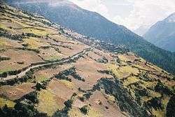
Ghyaru
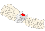
Ghyaru is a village development committee in Manang District in the Gandaki Zone of northern Nepal. At the time of the 2011 Nepal census it had a population of 71 people living in 33 individual households.[2]
.jpg)
Ghyaru घ्यारु | |
|---|---|
 | |
 Ghyaru Location in Nepal | |
| Coordinates: 28.66°N 84.15°E | |
| Country | |
| Zone | Gandaki Zone |
| District | Manang District |
| Elevation | 3,730 m (12,240 ft) |
| Population (2011)[1] | |
| • Total | 71 |
| Time zone | UTC+5:45 (Nepal Time) |
References
- "National Population and Housing Census 2011(Village Development Committee/Municipality)" (PDF). Government of Nepal. National Planning Commission. November 2012. Archived from the original (PDF) on 2018-10-05. Retrieved 2017-01-18.
- "Nepal Census 2001", Nepal's Village Development Committees, Digital Himalaya, archived from the original on 12 October 2008, retrieved 15 November 2009.
Manang District | ||
|---|---|---|
Headquarters: Chame Rural Municipality | ||
| Rural municipalities |
|  |
| Former VDCs | ||
This article is issued from Wikipedia. The text is licensed under Creative Commons - Attribution - Sharealike. Additional terms may apply for the media files.