Geronimo Trail Scenic Byway
Geronimo Trail Scenic Byway is a US National Scenic Byway commemorating Chiricahua Apache warrior Geronimo.[2] The road is also recognized by the New Mexico Department of Transportation as a scenic and historic byway.[3] The town of Truth or Consequences, New Mexico lies at the center of this trail with a southern end at San Lorenzo, Grant County, New Mexico and a northern end at Beaverhead Ranger Station. The Federal Highway Administration gives the total length of this scenic road as 154.0 mi (247.8 km).[1]
| Geronimo Trail Scenic Byway | |
|---|---|
| Route information | |
| Length | 154.0 mi[1] (247.8 km) |
| Component highways |
|
| Major junctions | |
| South end | |
| |
| North end | |
| Location | |
| Counties | Sierra and Grant |
| Highway system | |
| |
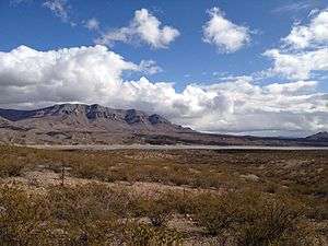
Geronimo Trail incorporates several New Mexico state highways passing along Elephant Butte Dam, Elephant Butte Lake State Park, Caballo Lake, Caballo Mountains and Black Range Mountains.[4] It is connected to the Trail of the Mountain Spirits Scenic Byway in the southwest and El Camino Real De Tierra Adentro in the northeast.[4][5][6] Towns along its southern route starting from San Lorenzo include Kingston, Hillsboro, Caballo, Williamsburg, and the ghost town of Lake Valley which is located 18 mi (29 km) south of the trail from Hillsboro on NM 27.[7][8] From Truth or Consequences north, there are Elephant Butte, New Mexico, Cuchillo, Winston and Chloride.[8][9]
References
- "Geronimo Trail Scenic Byway - America's Byways". Federal Highway Administration. Archived from the original on February 19, 2017. Retrieved February 19, 2017.
- Bellows, Keith (January 1, 2010). Drives of a Lifetime: 500 of the World's Most Spectacular Trips. National Geographic Books. p. 252. ISBN 9781426206771.
- "18.31.2 NMAC New Mexico Scenic and Historic Byways Program". New Mexico Administrative Code. February 27, 1998. Archived from the original on February 22, 2017. Retrieved February 22, 2017.
- "Geronimo Trail Scenic Byway - Directions". Federal Highway Administration. Archived from the original on February 22, 2017. Retrieved February 22, 2017.
- "Geronimo Trail Scenic Byway - Map". Federal Highway Administration. Retrieved February 22, 2017.
- "New Mexico Scenic Byways Map" (PDF). New Mexico Department of Transportation. July 1, 2015. Retrieved February 22, 2017.
- "The Southern Route". Geronimo Trail National Scenic Byway. Archived from the original on February 24, 2017. Retrieved February 24, 2017.
- "On The Rio Grande". Geronimo Trail National Scenic Byway. Archived from the original on February 24, 2017. Retrieved February 24, 2017.
- "The Northern Route". Geronimo Trail National Scenic Byway. Archived from the original on February 24, 2017. Retrieved February 24, 2017.