Garland, Kansas
Garland is an unincorporated community in Bourbon County, Kansas, United States. Garland is located along the Missouri state line 8.5 miles (13.7 km) southeast of Fort Scott.
Garland, Kansas | |
|---|---|
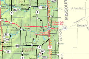 KDOT map of Bourbon County (legend) | |
| Coordinates: 37°43′54″N 94°37′21″W | |
| Country | United States |
| State | Kansas |
| County | Bourbon |
| Elevation | 853 ft (260 m) |
| Time zone | UTC-6 (CST) |
| • Summer (DST) | UTC-5 (CDT) |
| ZIP code | 66741 |
| Area code | 620 |
| GNIS ID | 475024[1] |
History
Garland was originally called Memphis. The name was changed to Garland (after a brand of stoves) when the railroad came through in the 1880s.[2]
Geography
Garland is located along the Missouri state line 8.5 miles (13.7 km) southeast of Fort Scott.
Further reading
References
- "US Board on Geographic Names". United States Geological Survey. 2007-10-25. Retrieved 2008-01-31.
- "Many Towns Have Disappeared". The Fort Scott Tribune. Jul 16, 1976. pp. 2C. Retrieved 16 May 2015.
External links
Municipalities and communities of Bourbon County, Kansas, United States | ||
|---|---|---|
| Cities | 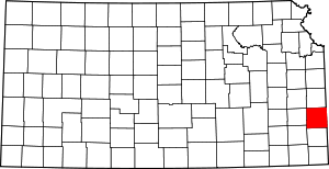 Map of Kansas highlighting Bourbon County | |
| Unincorporated communities | ||
| Townships | ||
This article is issued from Wikipedia. The text is licensed under Creative Commons - Attribution - Sharealike. Additional terms may apply for the media files.