Garfield, Georgia
Garfield is a city in Emanuel County, Georgia, United States. The population was 201 at the 2010 census,[5] up from 152 in 2000.
Garfield, Georgia | |
|---|---|
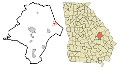 Location in Emanuel County and the state of Georgia | |
| Coordinates: 32°39′2″N 82°5′47″W | |
| Country | United States |
| State | Georgia |
| County | Emanuel |
| Area | |
| • Total | 0.80 sq mi (2.06 km2) |
| • Land | 0.79 sq mi (2.04 km2) |
| • Water | 0.01 sq mi (0.02 km2) |
| Elevation | 279 ft (85 m) |
| Population (2010) | |
| • Total | 201 |
| • Estimate (2018)[2] | 196 |
| • Density | 248.73/sq mi (96.00/km2) |
| Time zone | UTC-5 (Eastern (EST)) |
| • Summer (DST) | UTC-4 (EDT) |
| ZIP code | 30425 |
| Area code(s) | 478 |
| FIPS code | 13-32188[3] |
| GNIS feature ID | 0331791[4] |
History
The Georgia General Assembly incorporated the place as the Town of Garfield in 1905.[6]
Geography
Garfield is located in eastern Emanuel County at 32°39′2″N 82°5′47″W (32.650511, -82.096319).[7] Georgia State Route 23 passes through the city, leading northeast 14 miles (23 km) to Millen and southwest 6 miles (10 km) to Twin City. Swainsboro, the Emanuel County seat, is 16 miles (26 km) to the west.
According to the United States Census Bureau, Garfield has a total area of 0.81 square miles (2.1 km2), of which 0.01 square miles (0.02 km2), or 0.86%, is water.[5]
Demographics
| Historical population | |||
|---|---|---|---|
| Census | Pop. | %± | |
| 1910 | 319 | — | |
| 1920 | 416 | 30.4% | |
| 1930 | 342 | −17.8% | |
| 1940 | 291 | −14.9% | |
| 1950 | 213 | −26.8% | |
| 1960 | 225 | 5.6% | |
| 1970 | 214 | −4.9% | |
| 1980 | 222 | 3.7% | |
| 1990 | 255 | 14.9% | |
| 2000 | 152 | −40.4% | |
| 2010 | 201 | 32.2% | |
| Est. 2018 | 196 | [2] | −2.5% |
| U.S. Decennial Census[8] | |||
As of the census[3] of 2000, there were 152 people, 65 households, and 46 families residing in the town. The population density was 190.3 inhabitants per square mile (73.4/km²). There were 84 housing units at an average density of 105.2 per square mile (40.5/km²). The racial makeup of the town was 75.66% White and 24.34% African American.
There were 65 households out of which 33.8% had children under the age of 18 living with them, 44.6% were married couples living together, 23.1% had a female householder with no husband present, and 29.2% were non-families. 26.2% of all households were made up of individuals and 12.3% had someone living alone who was 65 years of age or older. The average household size was 2.34 and the average family size was 2.80.
In the town the population was spread out with 30.9% under the age of 18, 9.2% from 18 to 24, 19.7% from 25 to 44, 20.4% from 45 to 64, and 19.7% who were 65 years of age or older. The median age was 36 years. For every 100 females, there were 65.2 males. For every 100 females age 18 and over, there were 66.7 males.
The median income for a household in the town was $14,167, and the median income for a family was $22,500. Males had a median income of $36,875 versus $17,500 for females. The per capita income for the town was $16,038. About 27.1% of families and 36.4% of the population were below the poverty line, including 56.0% of those under the age of eighteen and 9.4% of those sixty five or over.
References
- "2018 U.S. Gazetteer Files". United States Census Bureau. Retrieved Feb 12, 2020.
- "Population and Housing Unit Estimates". Retrieved June 4, 2019.
- "U.S. Census website". United States Census Bureau. Retrieved 2008-01-31.
- "US Board on Geographic Names". United States Geological Survey. 2007-10-25. Retrieved 2008-01-31.
- "Geographic Identifiers: 2010 Demographic Profile Data (G001): Garfield city, Georgia". American Factfinder. U.S. Census Bureau. Archived from the original on February 13, 2020. Retrieved January 27, 2016.
- Acts and Resolutons of the General Assembly of the State of Georgia. State printer. 1905. p. 829.
- "US Gazetteer files: 2010, 2000, and 1990". United States Census Bureau. 2011-02-12. Retrieved 2011-04-23.
- "Census of Population and Housing". Census.gov. Retrieved June 4, 2015.
Municipalities and communities of Emanuel County, Georgia, United States | ||
|---|---|---|
| Cities |  Map of Georgia highlighting Emanuel County | |
| CDPs | ||
| Unincorporated communities | ||
| Footnotes | ‡This populated place also has portions in an adjacent county or counties | |