Gammertingen
Gammertingen is a town in the district of Sigmaringen, in Baden-Württemberg, Germany. It is situated 18 km north of Sigmaringen.
Gammertingen | |
|---|---|
 | |
 Coat of arms | |
Location of Gammertingen within Sigmaringen district 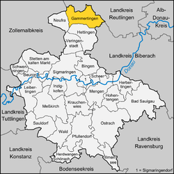 | |
 Gammertingen 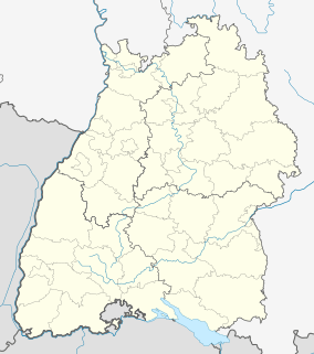 Gammertingen | |
| Coordinates: 48°14′58″N 9°13′3″E | |
| Country | Germany |
| State | Baden-Württemberg |
| Admin. region | Tübingen |
| District | Sigmaringen |
| Government | |
| • Mayor | Holger Jerg |
| Area | |
| • Total | 52.97 km2 (20.45 sq mi) |
| Elevation | 662 m (2,172 ft) |
| Population (2018-12-31)[1] | |
| • Total | 6,320 |
| • Density | 120/km2 (310/sq mi) |
| Time zone | CET/CEST (UTC+1/+2) |
| Postal codes | 72497–72501 |
| Dialling codes | 07574 |
| Vehicle registration | SIG |
| Website | www.gammertingen.de |
Geography
Geographical location
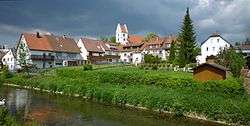
Gammertingen is located on the Swabian Jura in the valley of the Lauchert, a tributary of the Danube.
Neighbouring communities
The following cities and towns are adjacent to the city of Gammertingen. They are called the clockwise, starting in the Northeast:
Pfronstetten (Reutlingen (district)) Langenenslingen ( Biberach (district)) Hettingen, Neufra, Burladingen (Zollernalbkreis), Trochtelfingen (Reutlingen (district)).
Constituent communities
In addition to the core city of Gammertingen with around 5000 inhabitants belong to the whole city five districts, among them the three boroughs Feldhausen, Harthausen and Kettenacker together with the princely Hohenzollern domain Lusthof on the plateau of the Swabian Jura, Bronnen and Maria Berg.
History
The well-known Helmet of Gammertingen and other rich grave goods from a number of burial grounds provide the information of an early settlement in the time of the Merovingian dynasty. [2] Gammertingen was first mentioned in 1101 in a document of the Kloster Allerheiligen, Schaffhausen. Gammertingen was first mentioned in 1311 as a city. [3] During the time of the Hohenzollern and later Prussian times, Gammertingen was the seat of Oberamt, district court, forestry department and land registry.
During Nazi era was a camp of the female Reichsarbeitsdienst in Gammertingen.[4]
| Coat of arms | District | Inhabitants | Surface area |
|---|---|---|---|
| Gammertingen (main locality) | 5.000 | 1.769 ha | |
| Bronnen | > 500 | ? | |
| Feldhausen | ca. 400 | 991 ha | |
| Harthausen | ~ 250 | 671 ha | |
| Kettenacker | ca. 300 | 1.084 ha | |
| Mariaberg | > 500 | ? |
Notable people
- John O. Henes (1852–1923), American businessman and philanthropist
References
- "Bevölkerung nach Nationalität und Geschlecht am 31. Dezember 2018". Statistisches Landesamt Baden-Württemberg (in German). July 2019.
- Angela Vielstich, Edwin Ernst Weber: Der »Dreiländerkreis« Sigmaringen im geschichtlichen Überblick. In: Dirk Gaerte (Hrsg.); Edwin Ernst Weber (Konzeption): Der Dreiländerkreis Sigmaringen. Ein Führer zu Natur, Wirtschaft, Geschichte und Kultur. Gmeiner Verlag, Meßkirch 2007, ISBN 978-3-89977-512-9, S. 23–36, hier S. 24.
- Ludwig Eglers Chronik der Stadt Hechingen. Hechingen 1980, S. 14 Anmk.
- Edwin Ernst Weber: Sophie Scholl im Reichsarbeitsdienstlager Schloss Krauchenwies. In: Denkstättenkuratorium NS-Dokumentation Oberschwaben (Hrsg.): Denkorte an oberschwäbischen Erinnerungswegen in den Landkreisen Bodenseekreis und Sigmaringen. 2012. S. 30
Towns and municipalities in Sigmaringen | ||
|---|---|---|
| Authority control |
|
|---|