Gambia–Senegal border
The Gambia–Senegal border is 749 km (465 m) in length and runs on either side of the Gambia river.[1]
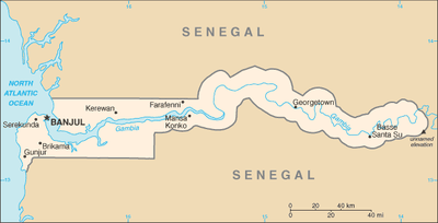
Description
In the north-west, the border starts at the Atlantic coast at Jinnak Creek, and then proceeds eastwards via a straight line.[2] Just to the west of the Gambian town of Ngeyen Sanjal the border proceeds to roughly parallel the north bank of the Gambia river at a distance of about 10km, bending round in the far east to encompass Koina and Kantale Kunde within Gambian territory, before proceeding westwards again at about 10km parallel to the river's southern bank. Just east of Dumbutu (Gambia) the boundary veers south in a straight line, then turns at a right angle to the west, proceeding via a straight line before reaching the San Pedro river; the boundary then follows this river out to the Atlantic Ocean.[2]
History

France and Britain began exploring and trading along the West African coast from the 17th century, and the two powers contended for supremacy in the Senegambia region over the following centuries. In 1821 Britain established a formal colony on the coast of modern Gambia, threatening nearby French coastal settlements.[3][4] The 1880s saw an intense competition between the European powers for territories in Africa, a process known as the Scramble for Africa. The process culminated in the Berlin Conference of 1884, in which the European nations concerned agreed upon their respective territorial claims and the rules of engagements going forward. As a result, France and Britain signed a treaty on 10 August 1889 delimiting a boundary between Gambia and Senegal, extending the Gambia east as far as Yarbutenda.[2] Various pillars were erected to mark the boundary on the ground, with further on-the-ground demarcation being conducted in 1911 and 1925.[2]
In 1960 France granted Senegal independence; Gambia became independent in 1965, at which point the border became an international one between two sovereign states.[2] In 1976 the two governments conducted some minor boundary adjustments in the far eastern section by mutual agreement.[2] From 1982-89 the two states were loosely united in the Senegambia Confederation.
References
- CIA World Factbook – Gambia, retrieved 13 January 2020
- Brownlie, Ian (1979). African Boundaries: A Legal and Diplomatic Encyclopedia. Institute for International Affairs, Hurst and Co. pp. 213–29.
- Thomas Pakenham (1991), The Scramble for Africa. London: Abacus. p. 675
- Klein, Martin A., Islam and Imperialism in Senegal Sine-Saloum, 1847–1914, p. 46. Published by Edinburgh University Press (1968). ISBN 0-85224-029-5