Hall Island (Arctic)
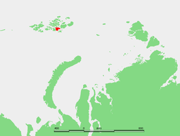
Hall Island (Russian: Остров Галля; Ostrov Gallya) is an island of the Russian Arctic archipelago of Franz Josef Land.
| Native name: | |
|---|---|
 | |
 | |
| Etymology | Charles Francis Hall |
| Geography | |
| Location | Arctic Ocean |
| Coordinates | 80°21′23″N 57°43′52″E |
| Archipelago | Franz Josef Land |
| Adjacent bodies of water | |
| Area | 1,049 km2 (405 sq mi) |
| Area rank | 314th |
| Coastline | 174.7 km (108.55 mi) |
| Highest elevation | 502 m (1,647 ft) |
| Highest point | Kupol Moskvy |
| Administration | |
Russia | |
| Federal subject | Arkhangelsk Oblast |
| Administrative district | Primorsky District |
| Demographics | |
| Population | 0 (2020) |
History
Hall Island was discovered on 30 August 1873, by the Austro-Hungarian North Pole expedition, and named after American Arctic explorer Charles Francis Hall. It was the first major island of the Franz Josef group on which the expedition members set foot.
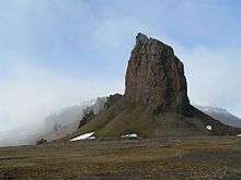
A small camp was built at Cape Tegethoff in 1898 by the Walter Wellman expedition. It contains a marker commemorating the discovery of the archipelago. Cape Tegethoff was named after the main ship of the Austro-Hungarian explorers, which had been named in honor of Austrian admiral Wilhelm von Tegetthoff.[1][2]
Geography
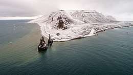
Hall Island is almost completely covered by glaciers. Its highest point is 502 m (1,647 ft) and it is the summit of the Kupol Moskvy ice dome that covers the central part of the island. Besides the ice dome there is a glacier with its terminus in the southern shore, the Sonklar Glacier.[3]
The only relatively large areas free of permanent ice are located in its southern end, where there are two headlands, Cape Tegethoff, and also Cape Ozernyy, on Littrov Peninsula. There is also a very small unglacierized area around its eastern cape, Mys Frankfurt, and another in its northwestern point, Cape Wiggins. Hall Island's area is 1,049 km2 (405 sq mi) and it is one of the largest islands in the group. There is a wide bay on the southeastern side of Hall Island known as Hydrographer Bay and a smaller one west of the Littrov Peninsula called Bukhta Surovaya.
Hall Island is located very close to the eastern shores of McClintock Island, separated from it by a narrow sound. To the southeast there is a wider strait separating Hall Island from Salm Island known in Russian as Proliv Lavrova. The strait to the east is the large Avstriskiy Proliv.
Adjacent minor islands
- Berghaus Island
- One and a half kilometres (1 mi) northeast off Hall Island's eastern bay; small but steep and unglacierized; highest point at 372 m (1,220 ft); named after German geographer Heinrich Berghaus
- Brownian Islands
- Three small island right off Hall Island's northern shore; named after Russian geographer and meteorologist Peter Ivanovich Brownov
- Newcomb Island
- Six kilometres (4 mi) west off Hall island's northwestern cape; five-kilometre-long (3 mi) oval-shaped and unglacierized; highest point at 67 m (220 ft); named after American naturalist Raymond Lee Newcomb of the ill-fated Jeannette expedition
See also
References
- Travellers and Explorers, 1846–1900. § 35. Arctic Exploration.
- Franklin Expedition and Arctic Exploration collection
- "Kupol Moskvy". Mapcarta. Retrieved 6 October 2016.