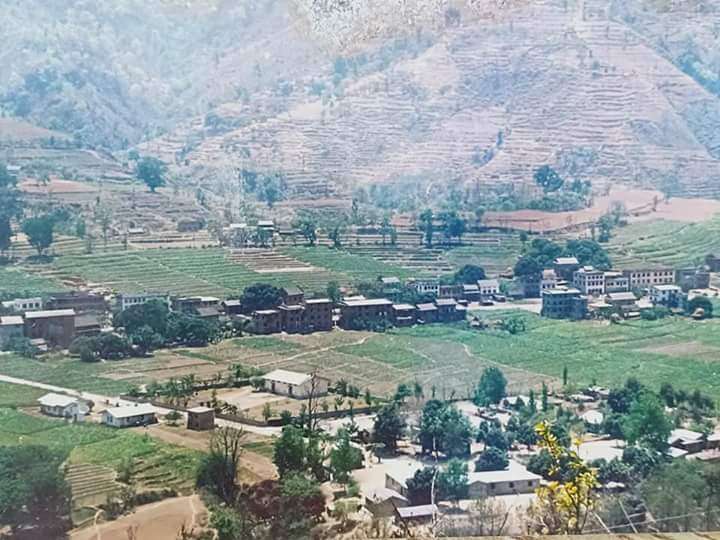
Gajuri
Gajuri(Nepali: गजुरी ; gajuri) is a Gaupalika (Nepali: गाउपालिका ; gaupalika)[2] (Formerly: village development committee) in Dhading District in the Bagmati Zone of central Nepal. It has a literacy rate of 64.28% (70.30% male and 58.41% female). The city hosts as one of the city with highest literacy rate in the Dhading district. The local body was formed by merging three VDCs namely Gajuri, Pida, Nepal, Kiranchok.[3]
Gajuri गजुरी (Nepali) | |
|---|---|
| Rural Municipality in Nepal | |
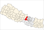
 Gajuri Location in Nepal | |
| Coordinates: 27.77°N 84.85°E | |
| Country | Nepal |
| Development Region | Central |
| Zone | Bagmati |
| District | Dhading |
| Province | Province No. 3 |
| Rural Municipality | Gajuri |
| Government | |
| • Chairperson | Mr.Rajendra Bikram Basnet (NCP) |
| • Vice-chairperson | Mrs.Sita Dhungana (NCP) |
| Area | |
| • Total | 138.66 km2 (53.54 sq mi) |
| Population (2017)[1] | |
| • Total | 27,084 |
| • Density | 200/km2 (510/sq mi) |
| • Religions | Hindu, Muslim, Buddhist |
| Languages | |
| • Local | Nepali, Newar language, Tamang, Gurung, Magar |
| Time zone | UTC+5:45 (NST) |
| Postal Code | 45112 |
| Area code(s) | 010 |
| Literacy Rate | |
| Website | http://gajurimun.gov.np |
At the time of the 2011 Nepal census it had a population of 10,035 including 4,968 Male & 5,067 Female, being one of the most populated city in the district. The average household size was 4.51. Besides, it had 2,223 houses in this area.[4] According to the report, out of 2223 houses, around 1,884 had at least one facility like Radio, Television, Internet, etc.
During the collection of voters data for 2017 Nepalese local elections, the population of Gajuri was calculated to be 27084.
Rural Municipality
Gajuri was declared as Rural Municipality on March 10, 2017. The formation of Rural Municipality led to local level elections on May 14, 2017. Out of a population of 27084, there were 14169 total eligible voters. CPN (UML) won positions for both Chairperson and Vice-Chairperson with a vote count of 4336 and 4214 respectively.[1]
Transportation
Gajuri is connected to Kathmandu to the east and Malekhu to the west by Prithvi Highway.
Geography
Gajuri lies at the North-Western part of Dhading District to the south of Trishuli River and covers an area of 138.66 km2. The average altitude of Gajuri is 547 metres (1796 ft) above sea level.[5]
Demographics
Per 2011 Census, the total population of Gajuri was 10,035 out of which 4,968 were male and 5,067 female in 2,223 households. Average family size was 4.51[6]
Population
By Age[7]
| Sex | Total | 00 - 04 | 05 - 09 | 10 - 14 | 15 - 19 | 20 - 24 | 25 - 29 | 30 - 34 | 35 - 39 | 40 - 44 | 45 - 49 | 50 - 54 | 55 - 59 | 60 - 64 | 65 - 69 | 70 - 74 | 75 + |
|---|---|---|---|---|---|---|---|---|---|---|---|---|---|---|---|---|---|
| Both Sex | 10,035 | 1,001 | 1,261 | 1,346 | 1,148 | 878 | 796 | 604 | 556 | 533 | 408 | 399 | 286 | 245 | 184 | 146 | 244 |
| Male | 4,968 | 507 | 645 | 677 | 545 | 382 | 365 | 290 | 269 | 273 | 212 | 217 | 149 | 131 | 95 | 79 | 132 |
| Female | 5,067 | 494 | 616 | 669 | 603 | 496 | 431 | 314 | 287 | 260 | 196 | 182 | 137 | 114 | 89 | 67 | 112 |
By Literacy Rate[8]
| Sex | Pop. aged 5 and 5+ | Who can Read & Write | Who can Read only | Who can't read & write | Not Stated | Literacy Rate |
|---|---|---|---|---|---|---|
| Both Sex | 9,034 | 5,807 | 329 | 2,893 | 5 | 64.28 |
| Male | 4,461 | 3,136 | 171 | 1,152 | 2 | 70.30 |
| Female | 4,573 | 2,671 | 158 | 1,741 | 3 | 58.41 |
By Caste[9]
| Caste/Ethnicity | Total | Male | Female |
|---|---|---|---|
| All Caste | 10035 | 4968 | 5067 |
| Chhetree | 1301 | 620 | 681 |
| Brahman - Hill | 1776 | 878 | 898 |
| Magar | 525 | 244 | 281 |
| Tharu | 23 | 13 | 10 |
| Tamang | 2229 | 1120 | 1109 |
| Newar | 646 | 315 | 331 |
| Musalman | 75 | 52 | 23 |
| Kami | 597 | 298 | 299 |
| Gurung | 101 | 46 | 55 |
| Damai/Dholi | 375 | 195 | 180 |
| Thakuri | 18 | 8 | 10 |
| Sarki | 591 | 288 | 303 |
| Sanyasi/Dashnami | 74 | 41 | 33 |
| Gharti/Bhujel | 44 | 20 | 24 |
| Majhi | 17 | 10 | 7 |
| Chepang/Praja | 1405 | 711 | 694 |
| Ghale | 181 | 80 | 101 |
| Others | 57 | 29 | 28 |
Notable P
Hospitals
- Gajuri Hospital Pvt. Ltd[10]
Schools
- Munal Academy
- Jagadamba Boarding School
- Shree Adarsha Higher Secondary School
- Pawil Himal Academy
See also
References
- "Local Elections 2074 - Election Results Overview - Dhading - Gajuri". Retrieved 2017-06-02.
- "यसरी २ नगर र ११ गाउँपालिकामा बाँडिनेभयो धादिङलाई (स्पष्ट नक्सासहित)". Sajhapost. Nov 11, 2016.
- Nepal, MOFALD. "Final District 1-75 Corrected Last for RAJPATRA" (PDF). mofald.gov.np. Ministry of Federal Affairs and Local Development (Nepal). p. 166. Retrieved June 2, 2017.
- "Households by ownership of house/housing unit In use" (PDF). Nepal's Village Development Committees. Central Bureau of Statistics. Retrieved 2016-07-13.
- ElevationMap.net. "Elevation of Gajuri with altitude and height". elevationmap.net. Retrieved 2017-06-04.
- "A detailed Report" (PDF). Nepal's Village Development Committees. Central Bureau of Statistics. Retrieved 2016-07-13.
- "Population Distribution of Dhading, Page 28" (PDF). Nepal's Village Development Committees. Central Bureau of Statistics. Retrieved 2016-07-13.
- "Population Distribution of Dhading, Page 63" (PDF). Nepal's Village Development Committees. Central Bureau of Statistics. Retrieved 2016-07-13.
- "Population Distribution of Dhading, Page 37" (PDF). Nepal's Village Development Committees. Central Bureau of Statistics. Retrieved 2016-07-13.
- "Hospitals in Gajuri". Nepalyp. Retrieved 6 July 2016.
Headquarter: Dhading Besi | ||
| Gaupalika |
|  |
| Municipalities |
| |