Gaj Koniemłocki
Gaj Koniemłocki[2][3] (Polish pronunciation: [ˈɡaj kɔɲɛmˈwɔtskʲi]) is a village in the administrative district of Gmina Staszów, within Staszów County, Świętokrzyskie Voivodeship, in south-central Poland. It lies approximately 5 kilometres (3 mi) south-west of Staszów and 55 km (34 mi) south-east of the regional capital Kielce.[4]
Gaj Koniemłocki | |
|---|---|
Village | |
 Gaj Koniemłocki | |
| Coordinates: 50°31′33″N 21°08′08″E | |
| Country | |
| Voivodeship | Świętokrzyskie |
| County | Staszów |
| Gmina | Staszów |
| Sołectwo | Gaj Koniemłocki |
| Elevation | 199.2 m (653.5 ft) |
| Population (31 December 2009 at Census)[1] | |
| • Total | |
| Time zone | UTC+1 (CET) |
| • Summer (DST) | UTC+2 (CEST) |
| Postal code | 28–200 |
| Area code(s) | +48 15 |
| Car plates | TSZ |
The village has a population of ![]()
Based on other article, Gaj Koniemłocki by years 1975–1998 use to belong to Tarnobrzeg Voivodeship
Demography
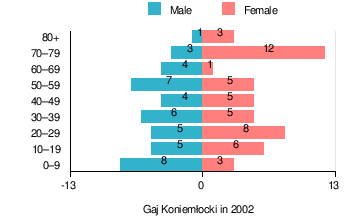
According to the 2002 Poland census, there were 91 people residing in Gaj Koniemłocki village, of whom 47.3% were male and 52.7% were female. In the village, the population was spread out with 22% under the age of 18, 33% from 18 to 44, 18.7% from 45 to 64, and 26.4% who were 65 years of age or older.[1]
Table 1. Population level of village in 2002 – by age group[1] SPECIFICATION Measure
unitPOPULATION
(by age group in 2002)TOTAL 0–9 10–19 20–29 30–39 40–49 50–59 60–69 70–79 80 + I. TOTAL person 91 11 11 13 11 9 12 5 15 4 — of which in % 100 12.1 12.1 14.3 12.1 9.9 13.2 5.5 16.5 4.4 1. BY SEX A. Males person 43 8 5 5 6 4 7 4 3 1 — of which in % 47.3 8.8 5.5 5.5 6.6 4.4 7.7 4.4 3.3 1.1 B. Females person 48 3 6 8 5 5 5 1 12 3 — of which in % 52.7 3.3 6.6 8.8 5.5 5.5 5.5 1.1 13.2 3.3
Figure 1. Population pyramid of village in 2002 – by age group and sex[1]
Table 2. Population level of village in 2002 – by sex[1] SPECIFICATION Measure
unitPOPULATION
(by sex in 2002)TOTAL Males Females I. TOTAL person 91 43 48 — of which in % 100 47.3 52.7 1. BY AGE GROUP A. At pre-working age person 20 13 7 — of which in % 22 14.3 7.7 B. At working age. grand total person 47 22 25 — of which in % 51.6 24.1 27.5 a. at mobile working age person 30 12 18 — of which in | % 33 13.2 19.8 b. at non-mobile working age person 17 10 7 — of which in | % 18.7 11 7.7 C. At post-working age person 24 8 16 — of which in % 26.4 8.8 17.6
References
- "Local Data Bank (Bank Danych Lokalnych) – Layout by NTS nomenclature (Układ wg klasyfikacji NTS)". demografia.stat.gov.pl: GUS. 10 March 2011.
- Bielec, Jan (ed.); Szwałek, Stanisława (1980). Wykaz urzędowych nazw miejscowości w Polsce. T. I: A – J [List of official names of localities in Poland, Vol. I: A – J] (in Polish). Ministry of Administration, Spatial Economy and Environmental Protection (1st ed.). Warsaw, Poland: Central Statistical Office.CS1 maint: extra text: authors list (link)
- "Gaj Koniemłocki, wieś, gmina Staszów – obszar wiejski, powiat staszowski, województwo świętokrzyski" [Gaj Koniemłocki, village, Staszów Commune – rural area, Staszów County, Świętokrzyskie Province, Poland]. Topographical map prepared in 1:10,000 scale. Aerial and satellite orthophotomap (in Polish). Head Office of Geodesy and Cartography, Poland, Warsaw. 2011. geoportal.gov.pl. Archived from the original on 21 December 2012. Retrieved 27 April 2011.
- "Central Statistical Office (GUS) – TERYT (National Register of Territorial Land Apportionment Journal)" (in Polish). 1 June 2008.
| Town and seat |  | |
|---|---|---|
| Parts of town |
| |
| Villages |
| |
| Parts of village |
| |
| Colonies |
| |
| Parts of colony |
| |
| Farmstead |
| |
| Hamlets |
| |
| Gamekeeper's cottage |
| |
| Forester's lodge |
| |