Gainesboro, Tennessee
Gainesboro is a town in Jackson County, Tennessee, United States. The population was 962 at the 2010 census. It is the county seat of Jackson County.[8]
Gainesboro, Tennessee | |
|---|---|
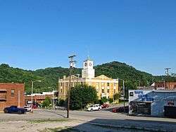 Jackson County Courthouse in Gainesboro | |
 Location of Gainesboro in Jackson County, Tennessee. | |
| Coordinates: 36°21′35″N 85°39′17″W | |
| Country | United States |
| State | Tennessee |
| County | Jackson |
| Settled | 1790s |
| Established | 1817[1] |
| Incorporated | 1905[2] |
| Named for | Edmund Pendleton Gaines |
| Area | |
| • Total | 1.78 sq mi (4.61 km2) |
| • Land | 1.56 sq mi (4.03 km2) |
| • Water | 0.22 sq mi (0.58 km2) |
| Elevation | 574 ft (175 m) |
| Population | |
| • Total | 962 |
| • Estimate (2018)[5] | 945 |
| • Density | 606.94/sq mi (234.40/km2) |
| Time zone | UTC-6 (Central (CST)) |
| • Summer (DST) | UTC-5 (CDT) |
| ZIP code | 38562 |
| Area code(s) | 931 |
| FIPS code | 47-28420[6] |
| GNIS feature ID | 1285070[7] |
| Website | www |
Gainesboro is part of the Cookeville, Tennessee Micropolitan Statistical Area.
History
The Gainesboro vicinity was a popular destination for long hunters as early as the 1770s, as natural salt licks drew rich game to the area. In the 1790s, Avery's Trace passed nearby, with travellers along the road lodging at Fort Blount about 10 miles to the west. Gainesboro was named after General Edmund Pendleton Gaines (1777–1849). It has been the seat of Jackson County since 1820.[9] The 1970 John Frankenheimer Movie "I Walk The Line" starring Gregory Peck and featuring Johnny Cash's song "I Walk The Line" was also filmed in Gainesboro.
Geography
According to the United States Census Bureau, Gainesboro is located approximately 15 miles northwest of Cookeville and has a total area of 1.8 square miles (4.7 km2), of which 1.6 square miles (4.1 km2) are land and 0.3-square-mile (0.78 km2) (14.29%) is water.[10]
Demographics
| Historical population | |||
|---|---|---|---|
| Census | Pop. | %± | |
| 1880 | 352 | — | |
| 1890 | 462 | 31.3% | |
| 1910 | 408 | — | |
| 1920 | 351 | −14.0% | |
| 1930 | 556 | 58.4% | |
| 1940 | 671 | 20.7% | |
| 1950 | 992 | 47.8% | |
| 1960 | 1,021 | 2.9% | |
| 1970 | 1,101 | 7.8% | |
| 1980 | 1,119 | 1.6% | |
| 1990 | 1,002 | −10.5% | |
| 2000 | 879 | −12.3% | |
| 2010 | 962 | 9.4% | |
| Est. 2018 | 945 | [5] | −1.8% |
| Sources:[11][12] | |||
As of the census[6] of 2000, there were 879 people, 373 households, and 208 families residing in the town. The population density was 562.5 people per square mile (217.6/km²). There were 430 housing units at an average density of 275.2 per square mile (106.4/km²). The racial makeup of the town was 98.29% White, 1.98% African American, 0.11% Native American, 0.46% Asian, 0.34% from other races, and 0.80% from two or more races. Hispanic or Latino of any race were 0.57% of the population.

There were 373 households, of which 16.9% had children under the age of 18 living with them, 36.2% were married couples living together, 13.9% had a female householder with no husband present, and 44.0% were non-families. 38.6% of all households were made up of individuals and 18.5% had someone living alone who was 65 years of age or older. The average household size was 2.00 and the average family size was 2.61.
In the town, the population was spread out with 13.5% under the age of 18, 8.8% from 18 to 24, 20.4% from 25 to 44, 26.6% from 45 to 64, and 30.7% who were 65 years of age or older. The median age was 51 years. For every 100 females, there were 68.7 males. For every 100 females age 18 and over, there were 67.4 males.
The median income for a household in the town was $19,861, and the median income for a family was $30,250. Males had a median income of $24,091 versus $21,932 for females. The per capita income for the town was $17,798. About 20.3% of families and 27.8% of the population were below the poverty line, including 49.0% of those under age 18 and 25.7% of those age 65 or over.
Notable people
- Charlotte Burks, Tennessee State Senator.
- Mounce Gore Butler - member of the United States House of Representatives.
- Alvan Cullem Gillem - Union army general.
- John J. Gore - United States District Court judge
References
- Laws of the State of Tennessee, Vol. 2 (Heiskell and Brown, 1821), p. 326.
- Tennessee Blue Book, 2005-2006, pp. 618-625.
- "2018 U.S. Gazetteer Files". United States Census Bureau. Retrieved February 23, 2020.
- Tennessee Department of Economic and Community Development, Certified Population of Tennessee Incorporated Municipalities and Counties Archived 2014-06-30 at the Wayback Machine, State of Tennessee website, 1 July 2011.
- "Population and Housing Unit Estimates". United States Census Bureau. June 27, 2019. Retrieved June 4, 2019.
- "U.S. Census website". United States Census Bureau. Retrieved 2008-01-31.
- "US Board on Geographic Names". United States Geological Survey. 2007-10-25. Retrieved 2008-01-31.
- "Find a County". National Association of Counties. Archived from the original on 2011-05-31. Retrieved 2011-06-07.
- The Federal Writers' Project, The WPA Guide to Tennessee (Knoxville, Tenn.: University of Tennessee Press, 1986), 445.
- "US Gazetteer files: 2010, 2000, and 1990". United States Census Bureau. 2011-02-12. Retrieved 2011-04-23.
- "Census of Population and Housing: Decennial Censuses". United States Census Bureau. Retrieved 2012-03-04.
- "Incorporated Places and Minor Civil Divisions Datasets: Subcounty Resident Population Estimates: April 1, 2010 to July 1, 2012". Population Estimates. U.S. Census Bureau. Archived from the original on 17 June 2013. Retrieved 11 December 2013.
External links
| Wikimedia Commons has media related to Gainesboro, Tennessee. |
- Official County Website
- Municipal Technical Advisory Service entry for Gainesboro – information on local government, elections, and link to charter
Municipalities and communities of Jackson County, Tennessee, United States | ||
|---|---|---|
| Town | Jackson County map | |
| CDP | ||
| Unincorporated communities | ||
| Authority control |
|
|---|