GOES 2
GOES-2, known as GOES-B before becoming operational, was a geostationary weather satellite which was operated by the United States National Oceanic and Atmospheric Administration as part of the Geostationary Operational Environmental Satellite system.[4] GOES-2 was built by Ford Aerospace, and was based on the satellite bus developed for the Synchronous Meteorological Satellite programme. At launch it had a mass of 295 kilograms (650 lb).[5] It was positioned in geostationary orbit, from where it was used for weather forecasting in the United States. Following its retirement as a weather satellite, it was used as a communications satellite until its final decommissioning in 2001.
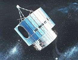 Artist's impression of an SMS-series GOES satellite in orbit | |
| Mission type | Weather satellite |
|---|---|
| Operator | NOAA / NASA |
| COSPAR ID | 1977-048A |
| SATCAT no. | 10061 |
| Mission duration | 24 years |
| Spacecraft properties | |
| Spacecraft type | SMS |
| Manufacturer | Ford Aerospace |
| Launch mass | 295 kilograms (650 lb) |
| Start of mission | |
| Launch date | 16 June 1977, 10:51:00 UTC |
| Rocket | Delta 2914 |
| Launch site | Cape Canaveral LC-17B |
| Contractor | McDonnell Douglas |
| End of mission | |
| Disposal | Decommissioned |
| Deactivated | 5 May 2001, 21:08 UTC |
| Orbital parameters | |
| Reference system | Geocentric |
| Regime | Geostationary |
| Longitude | 75° West (1977-1978) 100-110° West (1978-1984) 112-114° West (1984-1990) 60° West (1990-1992) 135° West (1992-1995) 177° West (1995-2001)[1][2] |
| Perigee altitude | 35,972 kilometres (22,352 mi) |
| Apogee altitude | 36,094 kilometres (22,428 mi) |
| Inclination | 13.7696º |
| Period | 24 hours |
| Epoch | 17 May 2016, 10:12:31 UTC[3] |
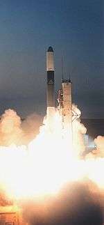
GOES-B was launched using a Delta 2914 carrier rocket flying from Launch Complex 17B at the Cape Canaveral Air Force Station.[2] The launch occurred at 10:51:00 GMT on 16 June 1977.[6] The launch successfully placed GOES-B into a geosynchronous transfer orbit, from which it raised itself to geostationary orbit by means of an onboard SVM-5 apogee motor. Its insertion into geosynchronous orbit occurred at 03:26 GMT on 17 June.[1]
Following on-orbit testing, GOES-B was redesignated GOES-2, and replaced SMS-1 at a longitude of 60 degrees west. It was operated as a weather satellite at several different positions until 1993, and was then placed into storage. It was reactivated as a communications satellite in 1995, and moved to 177° West. It was used by Peacesat to provide communications services to islands in the Pacific Ocean, a role in which it was replaced by GOES-7 in 1999, and by the US National Science Foundation for communications with the Amundsen-Scott South Pole Station. On 5 May 2001, it was retired to a graveyard orbit. At 21:08 GMT, two hours after the last manoeuvre to remove it from geosynchronous orbit, GOES-2 was commanded to deactivate its communications system, preventing future ground commands being sent to it.
See also
References
- McDowell, Jonathan. "Index". Geostationary Orbit Catalog. Jonathan's Space Page. Archived from the original on 2010-04-06. Retrieved 2009-08-12.
- Wade, Mark. "GOES". Encyclopedia Astronautica. Retrieved 2009-08-12.
- GOES-2 - Orbit. Heavens Above. Retrieved 2016-17-05.
- "GOES-2". The GOES Program - ESE 40th Anniversary. NASA. Retrieved 2009-08-12.
- Krebs, Gunter. "SMS 1, 2 / GOES 1, 2, 3". Gunter's Space Page. Retrieved 2009-08-12.
- McDowell, Jonathan. "Launch Log". Jonathan's Space Page. Retrieved 2009-08-12.
| SMS (predecessor) |  | |
|---|---|---|
| SMS derived | ||
| 1st generation | ||
| 2nd generation | ||
| 3rd generation | ||
| 4th generation | ||