Franconian Rezat
The Franconian Rezat (German: Fränkische Rezat) is a 77 km (48 mi) long river in southern Germany.[4] It is the western, left source river of the Rednitz.[5] It rises in the Franconian Heights near Oberdachstetten. It flows generally east through the towns Lehrberg, Ansbach, Windsbach and Spalt. Together with the Swabian Rezat (Schwäbische Rezat), it forms the Rednitz in Georgensgmünd.
| Franconian Rezat | |
|---|---|
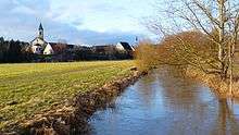
 The Franconian Rezat near Windsbach | |
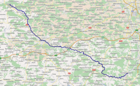 Course of the Franconian Rezat | |
| Location | |
| Location | Middle Franconia, Bavaria, Germany |
| Reference no. | DE: 242 |
| Physical characteristics | |
| Source | |
| ⁃ location | On the Franconian Heights northwest of Oberdachstetten |
| ⁃ coordinates | 49°25′39″N 10°23′47″E |
| ⁃ elevation | 452 m above sea level (NN) [1] |
| Mouth | |
⁃ location | Confluence: with the Swabian Rezat in Georgensgmünd to form the Rednitz |
⁃ coordinates | 49°11′17″N 11°01′20″E |
⁃ elevation | 342 m above sea level (NN) |
| Length | 77.3 km (48.0 mi) [2] |
| Basin size | 456 km2 (176 sq mi) [2] |
| Discharge | |
| ⁃ location | at Ansbach (26.3 % of the catchment) gauge[3] |
| ⁃ average | 744 l/s |
| ⁃ minimum | Record low: 20 l/s Average low: 158 l/s |
| ⁃ maximum | Average high: 19.9 m³/s Record high: 60.0 m³/s (in 1941) |
| Basin features | |
| Progression | Rednitz→ Regnitz→ Main→ Rhine→ North Sea |
 The Markgrafen Bridge at Windsbach
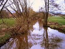
 The Franconian Rezat near Wassermungenau
 The Franconian Rezat near Georgensgmünd | |
References
- TOP 10 Bayern Nord
- Complete table of the Bavarian Waterbody Register by the Bavarian State Office for the Environment (xls, 10.3 MB)
- Bayerischer Hochwassernachrichtendienst Archived 2011-05-11 at the Wayback Machine (as at: 6 September 2011)
- Baedeker (Firm), Karl (1907). Southern Germany (Wurtemberg and Bavaria): Handbook for Travellers. K. Baedeker. p. 109.
Franconian Rezat, southern germany.
- "Rednitz - River". RouteYou. Retrieved 2019-11-27.
This article is issued from Wikipedia. The text is licensed under Creative Commons - Attribution - Sharealike. Additional terms may apply for the media files.