Fortifications of Vitré
The ramparts of Vitré are the fortifications built between the 13th and 17th centuries to protect the town of Vitré and Brittany against the French Kingdom. The city was located near the Breton border, near Maine, Anjou and Normandy. They cover an area of 8 hectares with a length of 500 m long and 200 m width. The fortifications of the thirteenth century are the best preserved in Brittany.
| Fortifications of Vitré | |
|---|---|
 Tour de la Bridole | |
| Location | Brittany, France |
| Nearest city | Vitré, Ille-et-Vilaine |
| Built | 1220–1591 (original fortifications) |
| Built for | Baron André III |
| Demolished | 19th c. (south ramparts) |
| Rebuilt | 19th, 20th, 21st c. |
| Architectural style(s) | Military |
| Governing body | Monument Historique |
| Designated | January 15th, 2014 |
Situation
The ramparts follow the contours of the rocky plateau where the Château de Vitré and the urban nucleus developing around the Church of Notre-Dame are built. The construction of the ramparts was made according to the defensive strengths and constraints of the relief.
The town is located on a plateau with very deep valleys. To the north flows the river Vilaine where there was a pond, swamps and a very high talus of 30 meters. The views over the landscape were excellent. In the south, the depression created by Vernouzet stream was an additional protection. The defensive fragility was to the east, direction from Laval and the French Kingdom, because access was so easy.
Vitré is located in the Armorican Massif, at the interface of zones of beige sandstone, and schists (argillites, black micaceous siltites, locally with ferruginous oolites). The ramparts are built with these materials available on the place. As a consequence, the exploitation of the stone has allowed the creation of large ditches to the south and east of the intramuros city of the order of 12 m (39 ft.) depth and a width of 20 m (66 ft.). A small supermarket in the rue de la Borderie has two levels of basement up to the level of the old ditches and illustrates these dimensions.
The inventory of the Baronnie de Vitré in 1681 testifies to the presence of springs and fountains in the moat, exploited by the inhabitants of the faubourgs for laundry, orchards and gardens.
History
The ramparts were built in 1240 by Baron Andrew III and reinforced with the development of artillery in the 15th century.
Vitré was a Protestant city, rich and prosperous. But during the religious wars, attacks by the Catholic leagues destroyed a part of the towers and ramparts east of the ancient city. At the end of the 16th century, a bastion was built in 1591.
The fortifications were destroyed in the south in the 19th century to connect the old town with the modern neighborhood. The Gare de Vitré arrived in 1857.
In 1987, the Tour des Claviers was discovered during the construction of a residential building. The old town is classified as a "remarkable heritage site" and the town borough engages in the renovation of this ramparts (Tour de la Bridole). All fortifications have been classified "historical monuments" on January 15, 2014.[1]
The remains of walls and towers are the most outstanding to the north and east of the intramuros of Vitré, along the Promenade du Val with exceptional point of view.
Plan of fortifications
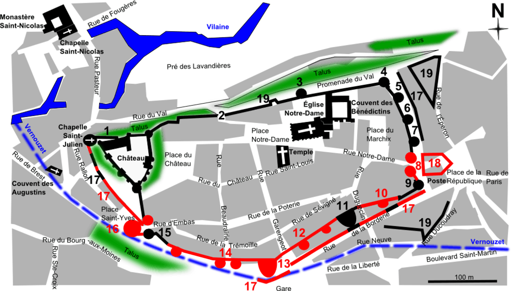
| Fortifications of Vitré |
||
| Saved components | Demolished components | |
|---|---|---|
| 1 : St. Julien Chapel and Faussebraye (North) | ||
| 2 : Postern St. Pierre | ||
| 3 : Tour aux Chèvres | ||
| 4 : Tour Rompue or Tour de la Fresnaye | ||
| 5 : Tour du Géomètre | ||
| 6 : Tour Doré | ||
| 7 : Tour des Prisonniers (Monument Historique) | ||
| 8 : Gate of En Haut (materialised between Rue Notre-Dame and Place de la République) | ||
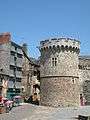
| 9 : Tour de la Bridole (or Tour du Coin or Tour du Marché) (Monument Historique) | ||
| 10: half-towers | ||
| 11: Tour des Claviers | ||
| 12: Tour de Sévigné | ||
| 13: Gate of Gâtesel | ||
| 14: Tour de Beaucé or "Horseshoe" | ||
| 15: Gate of Embas (South Tower) (Monument Historique) | 15: Gate of Embas (North Tower) | |
| 16: Barbican (materialised on the St. Yves Place) | ||
| 17: Counterscarp (Car park Rue Rallon) | ||
| 18: Barbican | ||
| 19: Bastion | ||
Gallery
 Gate of Embas (Porte d'Embas).
_Porte_d'Embas_02.JPG) Gate of Embas (Porte d'Embas) and Old Houses (15th c.).
Gate of Embas (Porte d'Embas) and Old Houses (15th c.). East fortifications built (13th c.).
References
- Mérimée PA00090906, Ministère français de la Culture. (in French) Enceinte urbaine fortifiée
- Daniel Pichot, Valérie Lagier et Gwenolé Allain, Vitré : Histoire et Patrimoine d'une Ville, Vitré, Somogy, Éditions d'Art, avril 2009, 295 p. (ISBN 978-2-7572-0207-4)
- Paul Banéat, Le Département d'Ille-et-Vilaine : Histoire - Archéologie - Monuments, t. IV, Mayenne, Éditions Régionales de l'Ouest, avril 1994, 584 p. (ISBN 2-85554-067-4)