Vilaine
The Vilaine (Breton: Gwilen) is a river in Brittany, in the west of France. The river's source is in the Mayenne département (53), and it flows out into the Atlantic Ocean at Pénestin in the Morbihan département (56). It is 218 km long.[1]
| Vilaine | |
|---|---|
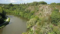
 The Vilaine in Rennes. | |
| Native name | La Vilaine (French) |
| Location | |
| Country | France |
| Physical characteristics | |
| Source | |
| ⁃ location | Juvigné, Mayenne |
| ⁃ coordinates | 48°13′46″N 01°03′11″W |
| ⁃ elevation | 175 m (574 ft) |
| Mouth | |
⁃ location | Atlantic Ocean |
⁃ coordinates | 47°30′20″N 2°29′57″W |
| Length | 218.1 km (135.5 mi) |
| Basin size | 10,882 km2 (4,202 sq mi) |
| Discharge | |
| ⁃ average | 80 m3/s (2,800 cu ft/s) |
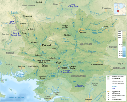
Course of the river
The river passes through 4 départements (Mayenne, Ille-et-Vilaine, Loire-Atlantique and Morbihan) and 4 main towns (Rennes, Vitré, Redon and La Roche-Bernard).
Three barrages were built around Vitré, Ille-et-Vilaine to alleviate flooding, while securing potable water supplies. They are also amenities for recreational activities.
- 1978 Valière barrage
- 1982 Haute-Vilaine barrage
- 1995 Villaumur barrage
Hydrology
The river has a flow ranging between 2 and 1500 m3/s
Navigation
The Vilaine is part of Brittany's canal system, built mainly in the 19th century for relatively small barges (130 tonnes). The entire system was transferred to the Brittany Region in 2011. In Rennes the river connects to the Canal d'Ille et Rance hence the Rance estuary, which enters the English Channel at Saint-Malo. In Redon it crosses the Canal de Nantes à Brest, giving access to Pontivy and the Blavet (west) and Nantes (east).
External links
- River Vilaine navigation guide; places, ports and moorings on the river, by the author of Inland Waterways of France, Imray
- Navigation details for 80 French rivers and canals (French waterways website section)