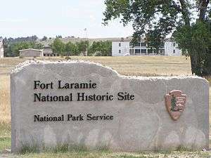
Fort Laramie, Wyoming
Fort Laramie is a town in Goshen County, Wyoming, United States. The population was 230 at the 2010 census. The town is named after historic Fort Laramie, an important stop on the Oregon, California and Mormon trails, as well as a staging point for various military excursions and treaty signings. The old fort was located south of town across the North Platte River, at the mouth of the Laramie River.
Fort Laramie, Wyoming | |
|---|---|
Town | |
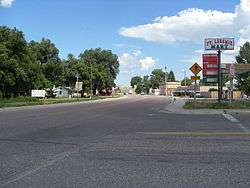 Main Street in Fort Laramie | |
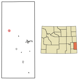 Location of Fort Laramie in Goshen County, Wyoming. | |
 Fort Laramie, Wyoming Location in the United States | |
| Coordinates: 42°12′48″N 104°31′2″W | |
| Country | |
| State | |
| County | |
| Area | |
| • Total | 0.25 sq mi (0.65 km2) |
| • Land | 0.25 sq mi (0.65 km2) |
| • Water | 0.00 sq mi (0.00 km2) |
| Elevation | 4,239 ft (1,292 m) |
| Population | |
| • Total | 230 |
| • Estimate (2018)[3] | 232 |
| • Density | 924.30/sq mi (356.23/km2) |
| Time zone | UTC-7 (Mountain (MST)) |
| • Summer (DST) | UTC-6 (MDT) |
| ZIP code | 82212 |
| Area code(s) | 307 |
| FIPS code | 56-28230[4] |
| GNIS feature ID | 1588642[5] |
History
In 1860 Fort Laramie served as a Pony Express station.
Geography
Fort Laramie is located at 42°12′48″N 104°31′2″W (42.213233, -104.517123).[6]
According to the United States Census Bureau, the town has a total area of 0.27 square miles (0.70 km2), all of it land.[7]
Climate
| Climate data for Old Fort Laramie (1989-2016) | |||||||||||||
|---|---|---|---|---|---|---|---|---|---|---|---|---|---|
| Month | Jan | Feb | Mar | Apr | May | Jun | Jul | Aug | Sep | Oct | Nov | Dec | Year |
| Record high °F (°C) | 68 (20) |
72 (22) |
80 (27) |
89 (32) |
98 (37) |
105 (41) |
106 (41) |
103 (39) |
102 (39) |
92 (33) |
80 (27) |
72 (22) |
106 (41) |
| Average high °F (°C) | 41.8 (5.4) |
43.8 (6.6) |
53.4 (11.9) |
60.6 (15.9) |
70.0 (21.1) |
81.1 (27.3) |
89.7 (32.1) |
88.1 (31.2) |
78.2 (25.7) |
63.8 (17.7) |
49.9 (9.9) |
41.1 (5.1) |
63.5 (17.5) |
| Average low °F (°C) | 12.3 (−10.9) |
13.4 (−10.3) |
21.7 (−5.7) |
28.9 (−1.7) |
38.6 (3.7) |
47.4 (8.6) |
54.0 (12.2) |
51.8 (11.0) |
40.8 (4.9) |
28.7 (−1.8) |
18.7 (−7.4) |
11.6 (−11.3) |
30.7 (−0.7) |
| Record low °F (°C) | −27 (−33) |
−36 (−38) |
−10 (−23) |
7 (−14) |
18 (−8) |
28 (−2) |
37 (3) |
31 (−1) |
20 (−7) |
−7 (−22) |
−14 (−26) |
−40 (−40) |
−40 (−40) |
| Average precipitation inches (mm) | 0.20 (5.1) |
0.43 (11) |
0.70 (18) |
1.71 (43) |
2.61 (66) |
2.38 (60) |
1.81 (46) |
1.51 (38) |
1.25 (32) |
1.16 (29) |
0.48 (12) |
0.39 (9.9) |
14.63 (370) |
| Average snowfall inches (cm) | 2.1 (5.3) |
4.1 (10) |
3.4 (8.6) |
2.2 (5.6) |
0.1 (0.25) |
0.0 (0.0) |
0.0 (0.0) |
0.0 (0.0) |
0.0 (0.0) |
2.1 (5.3) |
2.3 (5.8) |
4.9 (12) |
21.2 (52.85) |
| Average precipitation days (≥ 0.01 in) | 3 | 4 | 5 | 8 | 10 | 8 | 7 | 6 | 5 | 5 | 4 | 4 | 69 |
| Average snowy days (≥ 0.1 in) | 2 | 3 | 2 | 2 | 0 | 0 | 0 | 0 | 0 | 1 | 2 | 3 | 15 |
| Source: WRCC (https://wrcc.dri.edu/cgi-bin/cliMAIN.pl?wy6852)
Snowy days from Nowdata for Old Fort Laramie from the Cheyenne area | |||||||||||||
Demographics
| Historical population | |||
|---|---|---|---|
| Census | Pop. | %± | |
| 1930 | 245 | — | |
| 1940 | 311 | 26.9% | |
| 1950 | 300 | −3.5% | |
| 1960 | 233 | −22.3% | |
| 1970 | 197 | −15.5% | |
| 1980 | 356 | 80.7% | |
| 1990 | 243 | −31.7% | |
| 2000 | 243 | 0.0% | |
| 2010 | 230 | −5.3% | |
| Est. 2018 | 232 | [3] | 0.9% |
| U.S. Decennial Census | |||

2010 census
As of the census[2] of 2010, there were 230 people, 111 households, and 60 families residing in the town. The population density was 851.9 inhabitants per square mile (328.9/km2). There were 143 housing units at an average density of 529.6 per square mile (204.5/km2). The racial makeup of the town was 91.7% White, 1.3% Native American, 3.9% from other races, and 3.0% from two or more races. Hispanic or Latino of any race were 5.7% of the population.
There were 111 households of which 19.8% had children under the age of 18 living with them, 43.2% were married couples living together, 7.2% had a female householder with no husband present, 3.6% had a male householder with no wife present, and 45.9% were non-families. 43.2% of all households were made up of individuals and 19.8% had someone living alone who was 65 years of age or older. The average household size was 2.07 and the average family size was 2.88.
The median age in the town was 49.5 years. 18.3% of residents were under the age of 18; 4.7% were between the ages of 18 and 24; 20% were from 25 to 44; 32.6% were from 45 to 64; and 24.3% were 65 years of age or older. The gender makeup of the town was 53.5% male and 46.5% female.
2000 census
As of the census[4] of 2000, there were 243 people, 119 households, and 59 families residing in the town. The population density was 916.7 people per square mile (347.5/km²). There were 149 housing units at an average density of 562.1 per square mile (213.1/km²). The racial makeup of the town was 94.65% White, 1.23% Native American, 2.06% from other races, and 2.06% from two or more races. Hispanic or Latino of any race were 4.53% of the population.
There were 119 households out of which 20.2% had children under the age of 18 living with them, 39.5% were married couples living together, 6.7% had a female householder with no husband present, and 50.4% were non-families. 42.0% of all households were made up of individuals and 21.0% had someone living alone who was 65 years of age or older. The average household size was 2.04 and the average family size was 2.86.
In the town, the population was spread out with 21.8% under the age of 18, 4.5% from 18 to 24, 24.3% from 25 to 44, 25.9% from 45 to 64, and 23.5% who were 65 years of age or older. The median age was 45 years. For every 100 females, there were 91.3 males. For every 100 females age 18 and over, there were 84.5 males.
The median income for a household in the town was $22,500, and the median income for a family was $32,917. Males had a median income of $28,929 versus $13,125 for females. The per capita income for the town was $13,236. About 18.9% of families and 20.5% of the population were below the poverty line, including 23.3% of those under the age of eighteen and 12.5% of those sixty five or over.
Education
Public education for the town of Fort Laramie is provided by Goshen County School District #1.
Highways


Notable persons
- Innis P. Swift, United States Army general
See also
| Wikimedia Commons has media related to Fort Laramie, Wyoming. |
References
- "2018 U.S. Gazetteer Files". United States Census Bureau. Retrieved February 16, 2020.
- "U.S. Census website". United States Census Bureau. Retrieved December 14, 2012.
- "Population and Housing Unit Estimates". Retrieved June 4, 2019.
- "U.S. Census website". United States Census Bureau. Retrieved January 31, 2008.
- "US Board on Geographic Names". United States Geological Survey. October 25, 2007. Retrieved January 31, 2008.
- "US Gazetteer files: 2010, 2000, and 1990". United States Census Bureau. February 12, 2011. Retrieved April 23, 2011.
- "US Gazetteer files 2010". United States Census Bureau. Archived from the original on July 2, 2012. Retrieved December 14, 2012.
Municipalities and communities of Goshen County, Wyoming, United States | ||
|---|---|---|
| City |  | |
| Towns | ||
| CDPs | ||
| Unincorporated community | ||
| Authority control |
|
|---|