Fonda, New York
Fonda is a village in and the county seat of Montgomery County, New York, United States.[2] The population was 795 at the 2010 census. The village is named after Douw Fonda,[3] a Dutch-American settler who was scalped in 1780 during a Mohawk raid in the Revolutionary War, when they were allied with the British.
Fonda, New York | |
|---|---|
 Fonda, New York Location within the state of New York | |
| Coordinates: 42°57′16″N 74°22′32″W | |
| Country | United States |
| State | New York |
| County | Montgomery |
| Incorporated | 1850 |
| Area | |
| • Total | 0.6 sq mi (1.6 km2) |
| • Land | 0.5 sq mi (1.4 km2) |
| • Water | 0.1 sq mi (0.2 km2) |
| Elevation | 295 ft (90 m) |
| Population (2010) | |
| • Total | 795 |
| • Estimate (2018)[1] | 760 |
| • Density | 1,300/sq mi (500/km2) |
| Time zone | UTC-5 (Eastern (EST)) |
| • Summer (DST) | UTC-4 (EDT) |
| ZIP code | 12068 |
| Area code(s) | 518 Exchange: 853 |
| FIPS code | 36-26462 |
| GNIS feature ID | 0950363 |
The Village of Fonda is in the Town of Mohawk and is west of Amsterdam. In 1993, Mohawk bought land here to re-establish the Kanatsiohareke community formerly at this site. It is the first land they have held in the valley since being forced out in 1783 after the Revolution.[4]
The Fonda Fair is an annual agricultural event that takes place in August.
History

The village was developed near the site of the former Mohawk village of Caughnawaga, also known as Kanatsiohareke. Here the Mohawk had cultivated corn on the north side of the Mohawk River.
This became the 17th-century home of Kateri Tekakwitha, a Mohawk girl who converted to Catholicism and became renowned for her piety. She was living with relatives here after her parents died. It has a national shrine devoted to her; she is the first Native American saint. After a French attack on the village in the late 17th century, Kateri and many other Mohawk moved to a Jesuit mission village of Kahnawake, established opposite Montreal in Quebec, Canada on the south side of the St. Lawrence River.
European settlers, mostly German and English, officially organized the present-day village in 1751 at the site of Kanatsiohareke. The settlement was later named for Douw Fonda, a Dutch-American settler who was scalped in a Mohawk raid during the Revolutionary War.[3] His family were ancestors to the American actor Henry Fonda, who wrote about them in his 1981 autobiography, as follows:
Early records show the family ensconced in northern Italy in the 16th century where they fought on the side of the Reformation, fled to Holland, intermarried with Dutch burghers' daughters, picked up the first names of the Low Countries, but retained the Italianate "Fonda". Before Pieter Stuyvesant surrendered Nieuw Amsterdam to the English the Fondas, instead of settling in Manhattan, canoed up the Hudson River to the Indian village of Caughnawaga. Within a few generations, the Mohawks and the Iroquois were butchered or fled and the town became known to mapmakers as Fonda, New York.[5]
After the opening of the Erie Canal in 1825, Fonda thrived with the growth in trade and traffic that accompanied it. The canal provided transportation and commercial links to communities around the Great Lakes. Fonda became a center of cheesemaking, which was part of the regional dairy industry. The area was devoted to agriculture. As the county seat, it also did well with the arrival of the railroad in 1835, which increased cross-state transportation and shipping of goods. The village was incorporated in 1850.
In the mid to late-20th century, NASCAR held four races at the local Fonda Speedway (in 1955, 1966, 1967 and 1968) as part of the Fonda 200. In 1973 the Caughnawaga Indian Village Site was listed on the National Register of Historic Places. The Walter Butler Homestead was listed in 1976.[6]
In 1993 Tom Porter (Mohawk) re-established the first Mohawk community in the valley since 1783 by buying land in the Fonda area for cultivation of corn and other products. Other Mohawk joined him at this historic village site, naming their community Kanatsiohareke.[4]
Geography
Fonda is located at 42°57′16″N 74°22′32″W (42.954342, -74.375424).[7]
According to the United States Census Bureau, the village has a total area of 0.6 square miles (1.6 km2), of which, 0.5 square miles (1.3 km2) of it is land and 0.1 square miles (0.26 km2) of it (11.48%) is water.
Fonda is on the north bank of the Mohawk River opposite the Village of Fultonville.
New York State Route 5, New York State Route 30A, and New York State Route 334 all serve Fonda, with NY 334 having its southern terminus at NY 5 at the western end. Amtrak's Empire Corridor passes through the village, though no station is offered.
Demographics
| Historical population | |||
|---|---|---|---|
| Census | Pop. | %± | |
| 1870 | 1,092 | — | |
| 1880 | 944 | −13.6% | |
| 1890 | 1,190 | 26.1% | |
| 1900 | 1,145 | −3.8% | |
| 1910 | 1,100 | −3.9% | |
| 1920 | 2,208 | 100.7% | |
| 1930 | 1,170 | −47.0% | |
| 1940 | 1,123 | −4.0% | |
| 1950 | 1,026 | −8.6% | |
| 1960 | 1,004 | −2.1% | |
| 1970 | 1,120 | 11.6% | |
| 1980 | 1,006 | −10.2% | |
| 1990 | 1,007 | 0.1% | |
| 2000 | 810 | −19.6% | |
| 2010 | 795 | −1.9% | |
| Est. 2018 | 760 | [1] | −4.4% |
| U.S. Decennial Census[8] | |||
As of the census[9] of 2000, there were 810 people, 351 households, and 209 families residing in the village. The population density was 1,520.2 people per square mile (590.1/km²). There were 409 housing units at an average density of 767.6 per square mile (298.0/km²). The racial makeup of the village was 97.53% White, 0.37% African American, 0.25% Native American, 0.49% Asian, 0.12% Pacific Islander, 0.12% from other races, and 1.11% from two or more races. Hispanic or Latino of any race were 2.22% of the population.
There were 351 households out of which 29.9% had children under the age of 18 living with them, 36.2% were married couples living together, 17.4% had a female householder with no husband present, and 40.2% were non-families. 35.9% of all households were made up of individuals and 19.4% had someone living alone who was 65 years of age or older. The average household size was 2.29 and the average family size was 2.90.
In the village, the population was spread out with 25.4% under the age of 18, 8.0% from 18 to 24, 28.1% from 25 to 44, 19.4% from 45 to 64, and 19.0% who were 65 years of age or older. The median age was 36 years. For every 100 females, there were 82.4 males. For every 100 females age 18 and over, there were 78.7 males.
The median income for a household in the village was $28,021, and the median income for a family was $35,714. Males had a median income of $28,333 versus $23,500 for females. The per capita income for the village was $15,330. About 6.7% of families and 11.7% of the population were below the poverty line, including 13.9% of those under age 18 and 14.5% of those age 65 or over.
References
- "Population and Housing Unit Estimates". Retrieved February 29, 2020.
- "Find a County". National Association of Counties. Archived from the original on 2011-05-31. Retrieved 2011-06-07.
- Gannett, Henry (1905). The Origin of Certain Place Names in the United States. Govt. Print. Off. pp. 128.
- Sherene Baugher and Suzanne M. Spencer-Wood (2010). Archaeology and Preservation of Gendered Landscapes. Springer. p. 48.
- Henry Fonda, Howard Teichmann: My Life, New York: Dutton, 1981, p. 20, excerpted in: "The religious Affiliation of Henry Fonda, actor", Adherents, 21 July 2005, Retrieved on January 11, 2007
- "National Register Information System". National Register of Historic Places. National Park Service. March 13, 2009.
- "US Gazetteer files: 2010, 2000, and 1990". United States Census Bureau. 2011-02-12. Retrieved 2011-04-23.
- "Census of Population and Housing". Census.gov. Archived from the original on April 26, 2015. Retrieved June 4, 2015.
- "American FactFinder". United States Census Bureau. Archived from the original on 2020-02-12. Retrieved 2008-01-31.
External links
Municipalities and communities of Montgomery County, New York, United States | ||
|---|---|---|
| City | 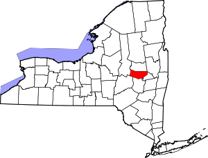 | |
| Towns | ||
| Villages | ||
| CDP | ||
| Hamlets | ||
| Footnotes | ‡This populated place also has portions in an adjacent county or counties | |
| Authority control |
|
|---|