Florencio Varela Partido
Florencio Varela is a partido in the south of Gran Buenos Aires urban area in Buenos Aires Province, Argentina.
Florencio Varela Partido de Florencio Varela | |
|---|---|
 Aerial view of San Juan Bautista square. Argentinian Biological Institute. Monteagudo pedestrian zone. Schönstatt Sanctuary. José de San Martín Monument. "Guillermo Enrique Hudson" ecological and cultural park. Ruins of the St. John Scottish Presbyterian Chapel. | |
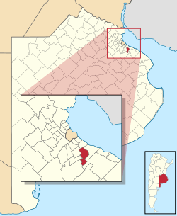 location of in Buenos Aires Province | |
| Coordinates: 34°49′S 58°17′W | |
| Country | Argentina |
| Established | 30 January 1891 |
| Seat | Florencio Varela |
| Government | |
| • Mayor | Andrés Watson |
| Area | |
| • Total | 190 km2 (70 sq mi) |
| Population | |
| • Total | 423,992 |
| • Density | 2,200/km2 (5,800/sq mi) |
| Demonym(s) | varelense |
| Postal Code | B1888 |
| IFAM | |
| Area Code | 011 |
| Website | www |
The partido has an area of 190 km2 (73 sq mi) and a population of 423,992 (2010 census [INDEC]).[1] Its capital is Florencio Varela.
Name
The partido is named in honour of Argentine writer and journalist Florencio Varela.
Districts
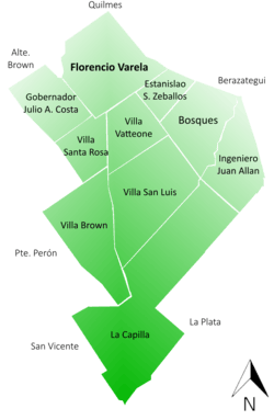
List of Districts in the partido, and their population (2001 census [INDEC])
- Bosques (51,663)
- Estanislao Severo Zeballos (20,967)
- Florencio Varela (120,678)
- Gobernador Julio A. Costa (49,291)
- Ingeniero Juan Allan (26,602)
- Villa Brown (6,034)
- Villa San Luis (10,234)
- Villa Santa Rosa (22,017)
- Villa Vatteone (35,985)
- La Capilla (5,499)
References
- "2010 Census provisional results". Archived from the original on 2012-09-01. Retrieved 2011-03-07.
External links

- (in Spanish) History of the partido
- (in Spanish) Florencio Varela news
This article is issued from Wikipedia. The text is licensed under Creative Commons - Attribution - Sharealike. Additional terms may apply for the media files.