Fleury-devant-Douaumont
Fleury-devant-Douaumont is a commune in the Meuse department in Grand Est in north-eastern France.
Fleury-devant-Douaumont | |
|---|---|
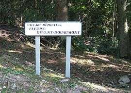 Sign indicating the site of the destroyed village | |
.svg.png) Coat of arms | |
Location of Fleury-devant-Douaumont 
| |
 Fleury-devant-Douaumont  Fleury-devant-Douaumont | |
| Coordinates: 49°11′44″N 5°26′07″E | |
| Country | France |
| Region | Grand Est |
| Department | Meuse |
| Arrondissement | Verdun |
| Canton | Belleville-sur-Meuse |
| Intercommunality | Grand Verdun |
| Government | |
| • Mayor (2014-2020) | Jean-Pierre Laparra |
| Area 1 | 10.27 km2 (3.97 sq mi) |
| Population (2016) | 0 |
| • Density | 0.0/km2 (0.0/sq mi) |
| Time zone | UTC+01:00 (CET) |
| • Summer (DST) | UTC+02:00 (CEST) |
| INSEE/Postal code | 55189 /55100 |
| Elevation | 227–390 m (745–1,280 ft) |
| 1 French Land Register data, which excludes lakes, ponds, glaciers > 1 km2 (0.386 sq mi or 247 acres) and river estuaries. | |
During the Battle of Verdun in 1916 it was captured and recaptured by the Germans and French sixteen times. Since then, it has been unoccupied (official population: 0) as had the communes of Bezonvaux, Beaumont-en-Verdunois, Haumont-près-Samogneux, Louvemont-Côte-du-Poivre, and Cumières-le-Mort-Homme.
History
During the war, the town was completely destroyed and the land was made uninhabitable to such an extent that a decision was made not to rebuild it. The area around the municipality was contaminated by corpses, explosives and poisonous gas, so no farmers could take up their work. The site of the commune is maintained as a testimony to war and is officially designated as a "village that died for France." It is managed by a municipal council of three members appointed by the prefect of the Meuse department.
Before the war Fleury was a village of 422 that produced agriculture and woodworking. Today, it is a wooded area next to the Verdun Memorial. Arrows guide visitors to where the street and houses used to be.
See also
- Zone rouge (First World War)
- List of French villages destroyed in World War I
- Communes of the Meuse department
References
| Wikimedia Commons has media related to Fleury-devant-Douaumont. |
| Authority control |
|
|---|