Flaxweiler
Flaxweiler (Luxembourgish: Fluessweiler) is a commune and small town in south-eastern Luxembourg. It is part of the canton of Grevenmacher.
Flaxweiler Fluessweiler | |
|---|---|
 | |
 Coat of arms | |
 Map of Luxembourg with Flaxweiler highlighted in orange, and the canton in dark red | |
| Coordinates: 49.6653°N 6.3431°E | |
| Country | |
| Canton | Grevenmacher |
| Area | |
| • Total | 30.17 km2 (11.65 sq mi) |
| Area rank | 26th of 102 |
| Highest elevation | 387 m (1,270 ft) |
| • Rank | 63rd of 102 |
| Lowest elevation | 208 m (682 ft) |
| • Rank | 28th of 102 |
| Population (2018) | |
| • Total | 2,109 |
| • Rank | 70th of 102 |
| • Density | 70/km2 (180/sq mi) |
| • Density rank | 79th of 102 |
| Time zone | UTC+1 (CET) |
| • Summer (DST) | UTC+2 (CEST) |
| LAU 2 | LU0001103 |
| Website | flaxweiler.lu |
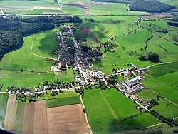
As of 2001, the town of Flaxweiler, which lies in the north-west of the commune, has a population of 338. Other towns within the commune include Beyren, Gostingen, Niederdonven, and Oberdonven.
The Mayor of Flaxweiler is the chief executive of the administration of the Luxembourgish commune of Flaxweiler. The incumbent mayor is Théo Weirich.
List of former mayors
| Name | Start | End |
|---|---|---|
| Michel Metzdorf | 1806 | 1810 |
| Pierre Stemper | 1810 | 1812 |
| Jean Nielles | 1813 | 1816 |
| François Strasser | 1816 | 1819 |
| Jean Huberty | 1819 | 1825 |
| Jean Peters (first time) | 1825 | 1830 |
| Michel Pettinger (first time) | 1830 | 1839 |
| Jean Peters (second time) | 1840 | 1848 |
| Michel Pettinger (second time) | 1848 | 1854 |
| Jean-Pierre Huberty | 1854 | 1867 |
| Michel Engel | 1867 | 1876 |
| Antoine Boss | 1876 | 1887 |
| Adolphe Musquar | 1889 | 1895 |
| Jean Molitor | 1895 | 1928 |
| Michel Schritz | 1929 | 1944[note 1] |
| Jean Sturm | 1945 | 1945 |
| Edouard Steffes | 1946 | 1965 |
| Eugène Kauffmann | 1966 | 1970 |
| Roger Lenert | 1970 | 2005 |
| Théo Weirich | 2005 | present (re-elected 2011)[1] |
Footnotes
- Mayor in name only under Nazi occupation (1940 - 1944)
References
- "Bestätigung für Théo Weirich" (in German). Luxembourg City, Luxembourg: Lëtzebuerger Journal. 9 October 2011. Retrieved 26 August 2012.
External links

- (in French) Official website
- "Flaxweiler - Découvrir la commune" (in French). Commune of Flaxweiler. Archived from the original on 7 May 2011. Retrieved 25 August 2012.
Places adjacent to Flaxweiler | ||||||||||
|---|---|---|---|---|---|---|---|---|---|---|
| ||||||||||
 | ||
| Authority control |
|
|---|
This article is issued from Wikipedia. The text is licensed under Creative Commons - Attribution - Sharealike. Additional terms may apply for the media files.