Flamsteed (crater)
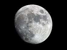
Flamsteed is a small lunar impact crater located on the Oceanus Procellarum, which is named after British astronomer John Flamsteed.[1] It lies almost due east of the dark-hued Grimaldi, and north-northwest of the flooded Letronne bay on the south edge of the mare.


 Lunar Orbiter 4 image | |
| Coordinates | 4.5°S 44.3°W |
|---|---|
| Diameter | 21 km |
| Depth | 2.2 km |
| Colongitude | 44° at sunrise |
| Eponym | John Flamsteed |
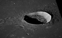
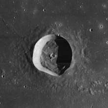
The rim of this crater is not circular in form, having a bulging rim to the southeast. The interior is relatively flat and undistinguished by impacts. The crater lies within the southern rim of a crater that has been almost completely submerged by the basaltic lava flows that formed the Oceanus Procellarum. All that remains of this feature designated Flamsteed P are some low ridges and hills arranged in a circular formation.
The Surveyor 1 craft landed within the northeast rim of the buried Flamsteed P feature, about 50 kilometers north-northeast of the Flamsteed crater rim.
Satellite craters
By convention these features are identified on lunar maps by placing the letter on the side of the crater midpoint that is closest to Flamsteed.
| Flamsteed | Latitude | Longitude | Diameter |
|---|---|---|---|
| A | 7.9° S | 42.9° W | 11 km |
| B | 5.9° S | 43.7° W | 10 km |
| C | 5.5° S | 46.3° W | 9 km |
| D | 3.2° S | 44.9° W | 6 km |
| E | 3.7° S | 46.1° W | 2 km |
| F | 4.7° S | 41.1° W | 5 km |
| G | 4.8° S | 50.9° W | 46 km |
| H | 5.9° S | 51.7° W | 4 km |
| J | 6.6° S | 49.3° W | 5 km |
| K | 3.1° S | 43.7° W | 4 km |
| L | 3.4° S | 40.9° W | 4 km |
| M | 2.4° S | 40.6° W | 4 km |
| P | 3.2° S | 44.1° W | 112 km |
| S | 3.4° S | 52.2° W | 4 km |
| T | 3.1° S | 51.6° W | 24 km |
| U | 3.6° S | 50.2° W | 4 km |
| X | 2.3° S | 47.3° W | 3 km |
| Z | 1.3° S | 47.8° W | 3 km |
References
- "Gazetteer of Planetary Nomenclature | Flamsteed". usgs.gov. International Astronomical Union. Retrieved August 29, 2017.
- Andersson, L. E.; Whitaker, E. A. (1982). NASA Catalogue of Lunar Nomenclature. NASA RP-1097.CS1 maint: ref=harv (link)
- Bussey, B.; Spudis, P. (2004). The Clementine Atlas of the Moon. New York: Cambridge University Press. ISBN 978-0-521-81528-4.CS1 maint: ref=harv (link)
- Cocks, Elijah E.; Cocks, Josiah C. (1995). Who's Who on the Moon: A Biographical Dictionary of Lunar Nomenclature. Tudor Publishers. ISBN 978-0-936389-27-1.CS1 maint: ref=harv (link)
- McDowell, Jonathan (July 15, 2007). "Lunar Nomenclature". Jonathan's Space Report. Retrieved 2007-10-24.CS1 maint: ref=harv (link)
- Menzel, D. H.; Minnaert, M.; Levin, B.; Dollfus, A.; Bell, B. (1971). "Report on Lunar Nomenclature by the Working Group of Commission 17 of the IAU". Space Science Reviews. 12 (2): 136–186. Bibcode:1971SSRv...12..136M. doi:10.1007/BF00171763.CS1 maint: ref=harv (link)
- Moore, Patrick (2001). On the Moon. Sterling Publishing Co. ISBN 978-0-304-35469-6.CS1 maint: ref=harv (link)
- Price, Fred W. (1988). The Moon Observer's Handbook. Cambridge University Press. ISBN 978-0-521-33500-3.CS1 maint: ref=harv (link)
- Rükl, Antonín (1990). Atlas of the Moon. Kalmbach Books. ISBN 978-0-913135-17-4.CS1 maint: ref=harv (link)
- Webb, Rev. T. W. (1962). Celestial Objects for Common Telescopes (6th revised ed.). Dover. ISBN 978-0-486-20917-3.CS1 maint: ref=harv (link)
- Whitaker, Ewen A. (1999). Mapping and Naming the Moon. Cambridge University Press. ISBN 978-0-521-62248-6.CS1 maint: ref=harv (link)
- Wlasuk, Peter T. (2000). Observing the Moon. Springer. ISBN 978-1-85233-193-1.CS1 maint: ref=harv (link)
External links
- Lunar Orbiter 1 photo 192, showing the northeastern part of Flamsteed P, where Surveyor 1 landed
| Wikimedia Commons has media related to Flamsteed (crater). |